

Storm description, surface observations, snowfall totals, and images courtesy of the National Climatic Data Center, the National Centers of Environmental Prediction, the Climate Prediction Center, the Hydrometeorological Prediction Center, the Mount Holly National Weather Service Office, the Upton National Weather Service Office, Rutgers University, Plymouth State University, the University of Illinois, the American Meteorological Society, Weather Graphics Technologies, AccuWeather, and the Weather Channel.
Table of Contents
Storm Summary
Regional Surface Observations
National Weather Service Forecasts
Surface Maps
Satellite Imagery
National Surface Weather Maps - Pressure and Fronts Only
Continental Surface Weather Maps - Pressure and Fronts Only
Sea Level Pressure and 1000 to 500 Millibar Thickness Maps
850 Millibar Maps
700 Millibar Maps
500 Millibar Maps
300 Millibar Maps
200 Millibar Maps
National Radar Imagery
Regional Radar Imagery
Fort Dix Doppler Radar Imagery
Storm Photos
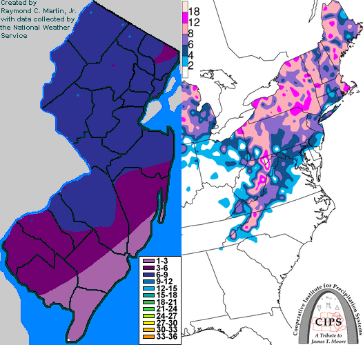
Contoured Snowfall Totals from February 28-March 1, 2005
STORM DESCRIPTION
A complex storm system from the Gulf of Mexico and the central Rockies brought the third snowstorm in 8 days to New Jersey.
Synoptic Discussion
A low pressure system emerged onto the High Plains of Colorado from the central Rockies during the day on the 26th. Meanwhile, another storm sytem developed along a stationary front in the Gulf of Mexico on the evening of the 26th. By the morning of the 27th, the low from the Rockies had moved into Minnesota, while the low from the Gulf had moved into the north-central Gulf of Mexico. Meanwhile, during the day on the 27th, a fresh batch of colder air moved southeastward from Canada across the Northeast as high pressure built southward. By the evening of the 27th, the low from the Rockies had moved into the upper peninsula of Michigan, while the Gulf low was crossing the northern end of the Florida peninsula. By the morning of the 28th, the low from the Rockies had slipped southward to Indiana, while the low from the Gulf was strengthening off the coast of North Carolina. By the evening of the 28th, the low from the Rockies was near the western end of Lake Erie, while the low from the Gulf had continued to strengthen and was due east of Virginia and due south of Rhode Island. By the morning of the 1st, the low from the Rockies was over the eastern half of Lake Erie, while the low from the Gulf was just east of Cape Cod. By the evening of the 1st, the low from the Rockies had weakened and been absorbed by the low from the Gulf, which was moving onshore in eastern Maine.
Local Discussion
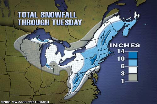
Snow spread slowly from south to north across the state during the day on the 28th. Across southern New Jersey, a wind from the ocean caused low-level temperatures to be just above freezing. This resulted in the snow mixing with rain at times, especially during the afternoon of the 28th. Colder air at the surface allowed precipitation to remain all snow further north. The snow became moderate to occasionally heavy as the low from the Gulf made its closest approach late in the afternoon and early in the evening of the 28th. Later in the evening on the 28th, the precipitation decreased in intensity and mixed with some sleet in southern New Jersey as warmer air moved in aloft, while precipitation remained mostly snow further north. Two final bursts of moderate to occasionally heavy snow rotated through the state during the late evening hours of the 28th and the early morning hours of the 1st as pieces of energy rotated around the large upper-level low located over the Midwest. The snow finally tapered off from south to north across the state around dawn on the 1st, though flurries and snow showers producing no additional accumulations redeveloped later in the day as the upper-level low moved by to the north. Snow accumulations were highest in the northern part of the state due to colder surface temperatures, ranging from 8 to 10 inches in Sussex County, 6 to 10 inches in Warren, Hunterdon and Essex counties, 6 to 9 inches in Passaic County, 6 to 8 inches in Mercer, Somerset and Union counties, 5 to 8 inches in Morris and Hudson counties, 4 to 8 inches in Bergen County, 2 to 8 inches in Burlington County, 6 to 7 inches in Middlesex and Camden counties, 4 to 7 inches in Monmouth and Gloucester counties, 5 to 6 inches in Salem County, 1 to 6 inches in Ocean County, 1 to 5 inches in Atlantic County, 1 to 4 inches in Cumberland County, and up to 1 inch in Cape May County.
New Jersey Snowfall Totals
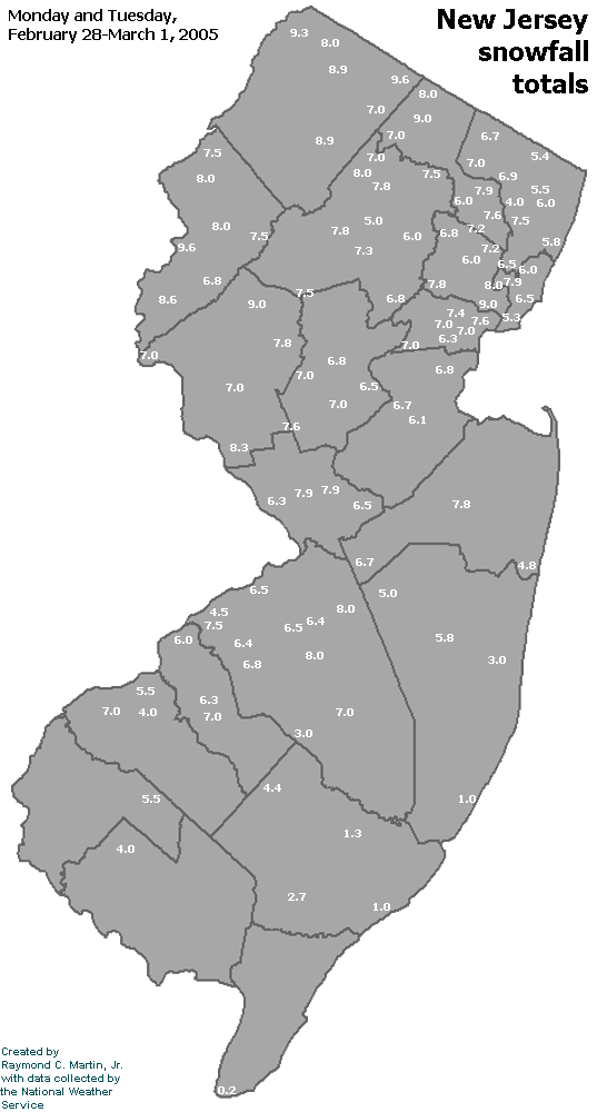
Individual Snowfall Totals from February 28-March 1, 2005
Regional Snowfall Totals
Final Snowfall Totals from February 28-March 1, 2005
Table of Contents
Storm Summary
Regional Surface Observations
National Weather Service Forecasts
Surface Maps
Satellite Imagery
National Surface Weather Maps - Pressure and Fronts Only
Continental Surface Weather Maps - Pressure and Fronts Only
Sea Level Pressure and 1000 to 500 Millibar Thickness Maps
850 Millibar Maps
700 Millibar Maps
500 Millibar Maps
300 Millibar Maps
200 Millibar Maps
National Radar Imagery
Regional Radar Imagery
Fort Dix Doppler Radar Imagery
Storm Photos
Snow storm, December 26-27, 2004
Snow storm, January 19, 2005
Snow storm, January 22-23, 2005
Snow storm, February 20-21, 2005
Snow storm, February 24-25, 2005
Snow storm, February 28-March 1, 2005
Snow storm, March 8, 2005
Back to Ray's Winter Storm Archive
Copyright © 2012 by Raymond C Martin Jr. All rights reserved