
US 1
Other Pictures
Douglas Kerr's Pictures
pictures / map / exit list / article (Steve Anderson)
Back to New Jersey Expressways and Tollways
|
||||||||||||||||||||||||
|
||||||||||||||||||||||||
| John Fitch Parkway (NJ 29) Northbound | John Fitch Parkway (NJ 29) Southbound | |||||||||||||||||||||||
|
|
|||||||||||||||||||||||
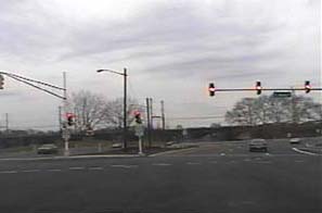
| This is the beginning of the John Fitch Parkway (NJ 29) northbound at South Warren Street in Trenton. Here, the short arterial John Fitch Parkway Extension (NJ 29) transitions to the full freeway John Fitch Parkway (NJ 29). Originally, this entire section was proposed to be full freeway, but community opposition prevented it. However, the NJDOT designed a very wide median into the project, quite possibly with the future intent of using the median to upgrade the arterial section to full freeway when future conditions warrant. Until reconstruction began in 1999, the current arterial section was the undivided John Fitch Way (NJ 29). The Penn Central Railroad viaduct across the Delaware RIver is visible ahead in the distance. Filmed March 2, 2002. |
||||||||||||||||||||||||
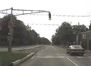
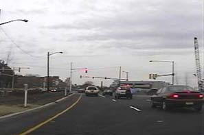
| This is the beginning of the freeway section of the John Fitch Parkway (NJ 29) southbound at Lee Avenue in Trenton. Despite maps which show otherwise, the John Fitch Parkway (NJ 29) and Daniel Bray Highway (NJ 29) north of Lee Avenue in Trenton and Ewing Township is not a full freeway, but rather a divided arterial with cross traffic. Only south of Lee Avenue is the John Fitch Parkway (NJ 29) a full freeway. Filmed July 31, 2000. |
||||||||||||||||||||||||
|
||||||||||||||||||||||||
|
||||||||||||||||||||||||
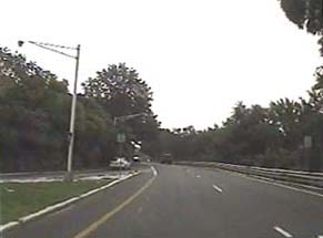
| This is the John Fitch Parkway (NJ 29) southbound north of Exit 4(Morrisville, Calhoun Street) in Trenton. The ramp merging from the left is the Parkside Avenue on-ramp. This ramp previously had a limited acceleration lane, but in 1999 and 2000 this area was partially reconstructed. The road was resurfaced with asphalt over the old cement, and the mainline lanes were realigned to extend the ramp's acceleration lane. New lights were also installed. Filmed July 31, 2000. |
||||||||||||||||||||||||
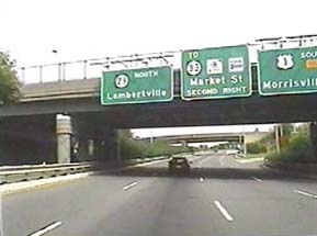
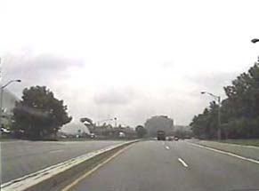
| This is the John Fitch Parkway (NJ 29) northbound at Exit 3(South US 1, To NJ 33, Market Street, Memorial Drive, Morrisville) in Trenton. Filmed July 31, 2000. |
||||||||||||||||||||||||
|
||||||||||||||||||||||||
|
||||||||||||||||||||||||
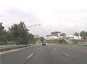
| This is the John Fitch Parkway (NJ 29) northbound north of Exit 3(South US 1, To NJ 33, Market Street, Memorial Drive, Morrisville) in Trenton. Part of the New Jersey State Capitol Complex is visible directly ahead. Filmed July 31, 2000. |
||||||||||||||||||||||||
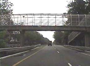
| This is the John Fitch Parkway (NJ 29) southbound just north of Exit 4(Morrisville, Calhoun Street) in Trenton. The pedestrian overpass connects residential Trenton with Stacy Park, Trenton's riverside park. The freeway took over half the previously existing parkland when it was constructed in the 1950's. Filmed July 31, 2000. |
||||||||||||||||||||||||
|
||||||||||||||||||||||||
|
||||||||||||||||||||||||
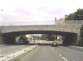
| This is the John Fitch Parkway (NJ 29) northbound at Exit 4(Calhoun Street, Morrisville) in Trenton. The "parkway" nature of the roadway begins to show in the stone-faced Calhoun Street overpass ahead. The cloverleaf interchange between the John Fitch Parkway (NJ 29) and Calhoun Street is among the tightest ever built, due to it being squeezed between the city of Trenton and the Delaware River. Also note the substandard median divider. Filmed July 31, 2000. |
||||||||||||||||||||||||
| This is the John Fitch Parkway (NJ 29) southbound at Exit 4(Morrisville, Calhoun Street) in Trenton. Part of the New Jersey State Capitol Complex is visible on the left, including the state planetarium. Note the substandard median divider. Filmed July 31, 2000. |
||||||||||||||||||||||||
|
||||||||||||||||||||||||
|
||||||||||||||||||||||||
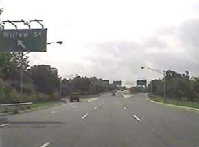
| This is the John Fitch Parkway (NJ 29) southbound at Exit 3(South US 1, To NJ 33, Memorial Drive, Market Street, Morrisville) in Trenton. The "Willow Street" exit on the left has since been resigned as "Memorial Drive". Filmed July 31, 2000. |
||||||||||||||||||||||||
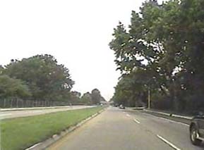
| This is the John Fitch Parkway (NJ 29) just south of Exit 5(Riverside Avenue, Hermitage Avenue, Parkside Avenue, South Eastfield Avenue, Cadwalder Park) in Trenton. This section shows more of the "parkway" nature of the road. In actuality, over half of Stacy Park (Trenton's riverside park) was taken to construct the freeway. The remainder is squeezed between the freeway and the river on the left. Filmed July 31, 2000. |
||||||||||||||||||||||||
|
||||||||||||||||||||||||
|
||||||||||||||||||||||||
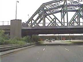
| This is the John Fitch Parkway (NJ 29) southbound south of Exit 3(South US 1, To NJ 33, Memorial Drive, Market Street, Morrisville) in Trenton. The bridge ahead is known as the "Trenton Makes, The World Takes" Bridge because that message is written out in neon lights on the south facing side. It is more simply known as the "Trenton Makes" bridge to locals. Filmed July 31, 2000. |
||||||||||||||||||||||||
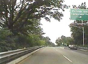
| This is the John Fitch Parkway (NJ 29) at Exit 5(Riverside Avenue, Hermitage Avenue, Parkside Avenue, South Eastfield Avenue, Cadwalder Park) in Trenton. The area around the Parkside Avenue ramps was refurbished with new lights and signage in 1999 and 2000. Filmed July 31, 2000. |
||||||||||||||||||||||||
|
||||||||||||||||||||||||
|
||||||||||||||||||||||||
| This is the end of the John Fitch Parkway (NJ 29) southbound at South Warren Street in Trenton. Here, the freeway John Fitch Parkway (NJ 29) transitions to the arterial John Fitch Parkway Extension (NJ 29). The freeway had been planned to continue here, but community opposition prevented it. However, the NJDOT designed the present arterial with a very wide median, presenting the possibility for a freeway upgrade in the future when conditions warrant. Before 1999, the road had continued south as the undivided John Fitch Way (NJ 29). Filmed March 2, 2002. |
||||||||||||||||||||||||
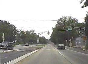
| This is the end of the freeway section of the John Fitch Parkway (NJ 29) at Lee Avenue in Trenton. Despite many erroneous maps, north of here the John Fitch Parkway (NJ 29) and Daniel Bray Highway (NJ 29) in Trenton and Ewing Township is only a divided arterial with cross traffic, not a full freeway. Filmed July 31, 2000. |
||||||||||||||||||||||||
| Connecting Pictures US 1 Other Pictures Douglas Kerr's Pictures pictures / map / exit list / article (Steve Anderson) Back to New Jersey Expressways and Tollways |
||||||||||||||||||||||||
| Copyright © 2002 by Raymond C Martin Jr. All rights reserved | ||||||||||||||||||||||||