

Storm description, surface observations, snowfall totals, and images courtesy of the National Climatic Data Center, the National Centers of Environmental Prediction, the Climate Prediction Center, the Hydrometeorological Prediction Center, the Mount Holly National Weather Service Office, the Upton National Weather Service Office, Rutgers University, Plymouth State University, the University of Illinois, the American Meteorological Society, Weather Graphics Technologies, AccuWeather, and the Weather Channel.
Table of Contents
Storm Summary
Regional Surface Observations
National Weather Service Forecasts
Surface Maps
Satellite Imagery
Sea Level Pressure and 1000 to 500 Millibar Thickness Maps
850 Millibar Maps
700 Millibar Maps
500 Millibar Maps
300 Millibar Maps
200 Millibar Maps
National Radar Imagery
Local Radar Imagery
Contoured Snowfall Totals from January 10-11, 1995
STORM DESCRIPTION
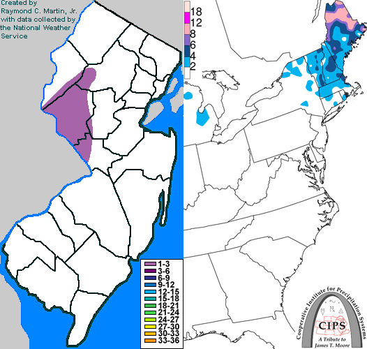
A light burst of wet snow blanketed west central New Jersey before changing to rain.
Synoptic Discussion
A warm front gradually moved northeastwards from the Mid-Atlantic and Ohio Valley. Overruning moisture from the Gulf of Mexico produced scattered bands of precipitation in advance of the front, and more concentrated rain in the warm sector behind it.
Local Discusion
Snow fell occasionally during the day on the 11th, while producing only a dusting to half-inch in most areas. During the evening hours, a more concentrated area of precipitation moved in from the west-southwest. Snow accumulated up to one slushy inch in parts of central New Jersey before changing to rain by 6PM EST. Futher northwest, temperatures remained below freezing for longer and a period of freezing rain fell across northwestern New Jersey during the night of the 11th.
New Jersey Snowfall Totals
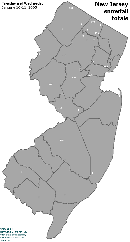
Individual Snowfall Totals from January 10-11, 1995
Table of Contents
Storm Summary
Regional Surface Observations
National Weather Service Forecasts
Surface Maps
Satellite Imagery
Sea Level Pressure and 1000 to 500 Millibar Thickness Maps
850 Millibar Maps
700 Millibar Maps
500 Millibar Maps
300 Millibar Maps
200 Millibar Maps
National Radar Imagery
Local Radar Imagery
Snow and ice storm, January 10-11, 1995
Snow storm, February 3-4, 1995
Snow storm, February 26, 1995
Back to Ray's Winter Storm Archive
Copyright © 2012 by Raymond C Martin Jr. All rights reserved