

Storm description, surface observations, snowfall totals, and images courtesy of the National Climatic Data Center, the National Centers of Environmental Prediction, the Climate Prediction Center, the Hydrometeorological Prediction Center, the Mount Holly National Weather Service Office, the Upton National Weather Service Office, Rutgers University, Plymouth State University, the University of Illinois, the American Meteorological Society, Weather Graphics Technologies, AccuWeather, and the Weather Channel.
Table of Contents
Storm Summary
Regional Surface Observations
National Weather Service Forecasts
Surface Maps
Satellite Imagery
Sea Level Pressure and 1000 to 500 Millibar Thickness Maps
850 Millibar Maps
700 Millibar Maps
500 Millibar Maps
300 Millibar Maps
200 Millibar Maps
National Radar Imagery
Local Radar Imagery
Fort Dix Doppler Radar Imagery
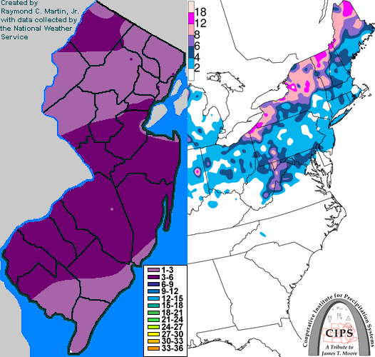
Contoured Snowfall Totals from January 8-9, 1999
STORM DESCRIPTION
A storm from the southern plains brought a mix of snow, sleet, and freezing rain across most of New Jersey.
Synoptic Discussion
A low pressure system developed over Texas during the morning of the 8th. A broad southwest flow ahead of it overran a frontal boundary over the central Appalachians and spread snow, sleet, and freezing rain across the Northeast. The low pressure system tracked northeast across western Pennsylvania and central New York, causing most areas to the east of the track to eventually turn over to plain rain before ending on the 9th.
Local Discusion
Snow began around 7 am EST in southwest New Jersey, which spread northeast and reached Staten Island, New York around 11 am EST. In interior southern New Jersey, sleet started to mix with the snow around 1 pm EST, and had gone over completely to freezing rain and sleet by 4 pm EST. The mixing with sleet and change to freezing rain took longer further to the north. At the same time, low-level warm air from the Atlantic Ocean was moving inland, turning the freezing rain over to rain, but this too was a slow process, with little freezing or frozen precipitation along the southern New Jersey coast and the most in the northwestern valleys. The freezing rain changed to rain by 4 pm EST on the 8th in Atlantic and Monmouth counties, by midnight EST on the 9th in Burlington County, by 2 am EST on the 9th in Mercer County, and not until around daybreak on the 9th in the northwestern valleys. Snow accumulations averaged between 2 and 5 inches, while ice accretion was around a tenth of an inch, increasing to a half inch in the northwestern valleys.
New Jersey Snowfall Totals
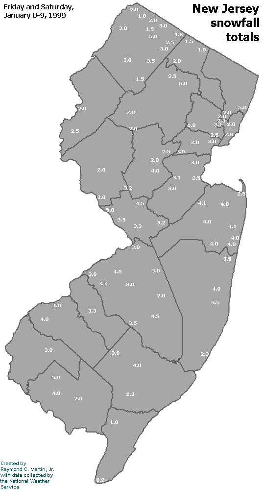
Individual Snowfall Totals from January 8-9, 1999
Table of Contents
Storm Summary
Regional Surface Observations
National Weather Service Forecasts
Surface Maps
Satellite Imagery
Sea Level Pressure and 1000 to 500 Millibar Thickness Maps
850 Millibar Maps
700 Millibar Maps
500 Millibar Maps
300 Millibar Maps
200 Millibar Maps
National Radar Imagery
Local Radar Imagery
Fort Dix Doppler Radar Imagery
Snow storm, December 23-24, 1998
Snow and ice storm, January 8-9, 1999
Ice storm, January 13-15, 1999
Snow storm, March 14-15, 1999
Back to Ray's Winter Storm Archive
Copyright © 2012 by Raymond C Martin Jr. All rights reserved