

Storm description, surface observations, snowfall totals, and images courtesy of the National Climatic Data Center, the National Centers of Environmental Prediction, the Climate Prediction Center, the Hydrometeorological Prediction Center, the Mount Holly National Weather Service Office, the Upton National Weather Service Office, Rutgers University, Plymouth State University, the University of Illinois, the American Meteorological Society, Weather Graphics Technologies, AccuWeather, and the Weather Channel.
Table of Contents
Storm Summary
Regional Surface Observations
National Weather Service Forecasts
Surface Maps
Satellite Imagery
National Surface Weather Maps - Pressure and Fronts Only
Sea Level Pressure and 1000 to 500 Millibar Thickness Maps
850 Millibar Maps
700 Millibar Maps
500 Millibar Maps
300 Millibar Maps
200 Millibar Maps
National Radar Imagery
Local Radar Imagery
Fort Dix Doppler Radar Imagery
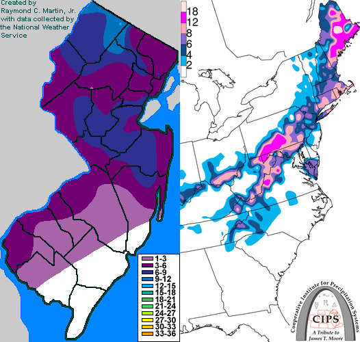
Contoured Snowfall Totals from March 14-15, 1999
STORM DESCRIPTION
A coastal low pressure system brought heavy wet snow to most of New Jersey from northern Burlington and Ocean Counties northward.
Synoptic Discussion
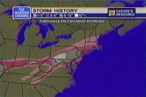
With cold air over the Northeast, a low pressure system developed along the Gulf Coast on the morning of the 13th. By the morning of the 14th, it had moved into Alabama and was slowly intensifying. By daybreak on the 15th the low was located just east of the Delmarva Penninsula. During the day on the 15th the storm intensified and rapidly moved off-shore, reaching Nova Scotia on the morning of the 16th.
Local Discusion
This was the heaviest snow to affect so much of the state simultaneously since 1997. As the low moved towards the Mid-Atlantic states during the day on the 14th, precipitation overspread the area. Precipitation started as snow in the early afternoon of the 14th in the northwestern part of the state. Farther south, the low-level air had warmed enough for precipitation to start as rain. However, as the intensity increased, the precipitation changed to snow in most areas between 2 pm and 4 pm EST. The wet snow became heavy overnight as the low approached the Mid-Atlantic coast. The rain/snow line had a difficult time lifting north of the Salem/Cumberland County line, western Atlantic County, southern Burlington County, and eastern Ocean County area. In Salem County, precipitation changed from snow to rain and back to snow until finally changing to rain for good during the late evening of the 14th. The snow changed to rain around midnight EST in Mt. Holly and changed to rain around 1 am EST in Trenton. Precipitation ended as snow in the northwest part of the state. Accumulations in southwest New Jersey averaged between 2 and 4 inches, while further north 4 to 8 inches was the rule, with isolated higher amounts.
New Jersey Snowfall Totals
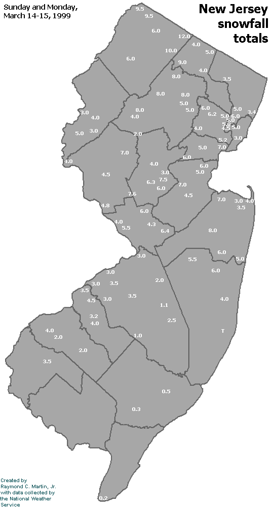
Individual Snowfall Totals from March 14-15, 1999
Regional Snowfall Totals
Snowfall totals from 0900Z 15 March 1999 (4AM EST 15 March 1999)
Table of Contents
Storm Summary
Regional Surface Observations
National Weather Service Forecasts
Surface Maps
Satellite Imagery
National Surface Weather Maps - Pressure and Fronts Only
Sea Level Pressure and 1000 to 500 Millibar Thickness Maps
850 Millibar Maps
700 Millibar Maps
500 Millibar Maps
300 Millibar Maps
200 Millibar Maps
National Radar Imagery
Local Radar Imagery
Fort Dix Doppler Radar Imagery
Snow storm, December 23-24, 1998
Snow and ice storm, January 8-9, 1999
Ice storm, January 13-15, 1999
Snow storm, March 14-15, 1999
Back to Ray's Winter Storm Archive
Copyright © 2012 by Raymond C Martin Jr. All rights reserved