

Storm description, surface observations, snowfall totals, and images courtesy of the National Climatic Data Center, the National Centers of Environmental Prediction, the Climate Prediction Center, the Hydrometeorological Prediction Center, the Mount Holly National Weather Service Office, the Upton National Weather Service Office, Rutgers University, Plymouth State University, the University of Illinois, the American Meteorological Society, Weather Graphics Technologies, AccuWeather, and the Weather Channel.
Table of Contents
Storm Summary
Regional Surface Observations
National Weather Service Forecasts
Surface Maps
Satellite Imagery
National Surface Weather Maps - Pressure and Fronts Only
Continental Surface Weather Maps - Pressure and Fronts Only
Sea Level Pressure and 1000 to 500 Millibar Thickness Maps
850 Millibar Maps
700 Millibar Maps
500 Millibar Maps
300 Millibar Maps
200 Millibar Maps
National Radar Imagery
Regional Radar Imagery
Fort Dix Doppler Radar Imagery
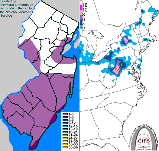
Contoured Snowfall Totals from March 07, 2007
STORM DESCRIPTION
A weak Alberta Clipper brought a period of snow to much of New Jersey, with the highest accumulations across the southern half of the state.
Synoptic Discussion
A strong cold front pushed southeastward across the state on Monday, March 5th. Behind the front, a bitterly cold arctic airmass pushed southward across the state from Canada. An Alberta Clipper moved southeastward from south-central Canada on Tuesday the 6th, passing south of the state on Wednesday the 7th. By the morning of Thursday the 8th, it had pushed off the mid-Atlantic coast.
Local Discussion
Light snow overspread most of the state from west to east around dawn on Wednesday the 7th. The snow continued at a light but steady clip through the morning, gradually tapering off from north to south during the afternoon. Accumulations were around 3 inches along the southeastern coast, ranged mainly from 1 to 3 inches across the rest of southern New Jersey, and were generally between a coating to 1 inch across the northern half of the state.
New Jersey Snowfall Totals
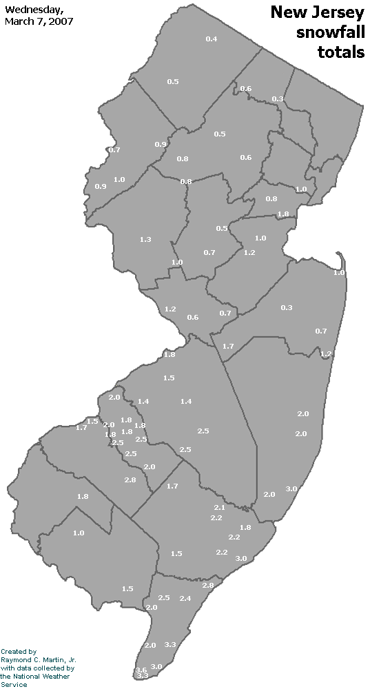
Individual Snowfall Totals from March 07, 2007
Table of Contents
Storm Summary
Regional Surface Observations
National Weather Service Forecasts
Surface Maps
Satellite Imagery
National Surface Weather Maps - Pressure and Fronts Only
Continental Surface Weather Maps - Pressure and Fronts Only
Sea Level Pressure and 1000 to 500 Millibar Thickness Maps
850 Millibar Maps
700 Millibar Maps
500 Millibar Maps
300 Millibar Maps
200 Millibar Maps
National Radar Imagery
Regional Radar Imagery
Fort Dix Doppler Radar Imagery
Snow storm, January 28-29, 2007
Snow and ice storm, February 13-14, 2007
Snow and ice storm, February 25-26, 2007
Snow storm, March 7, 2007
Ice storm, March 15-17, 2007
Back to Ray's Winter Storm Archive
Copyright © 2012 by Raymond C Martin Jr. All rights reserved