

Storm description, surface observations, snowfall totals, and images courtesy of the National Climatic Data Center, the National Centers of Environmental Prediction, the Climate Prediction Center, the Hydrometeorological Prediction Center, the Mount Holly National Weather Service Office, the Upton National Weather Service Office, Rutgers University, Plymouth State University, the University of Illinois, the American Meteorological Society, Weather Graphics Technologies, AccuWeather, and the Weather Channel.
Table of Contents
Storm Summary
Regional Surface Observations
National Weather Service Forecasts
Surface Maps
Satellite Imagery
National Surface Weather Maps - Pressure and Fronts Only
Continental Surface Weather Maps - Pressure and Fronts Only
Sea Level Pressure and 1000 to 500 Millibar Thickness Maps
850 Millibar Maps
700 Millibar Maps
500 Millibar Maps
300 Millibar Maps
200 Millibar Maps
National Radar Imagery
Regional Radar Imagery
Fort Dix Doppler Radar Imagery
Storm Photos
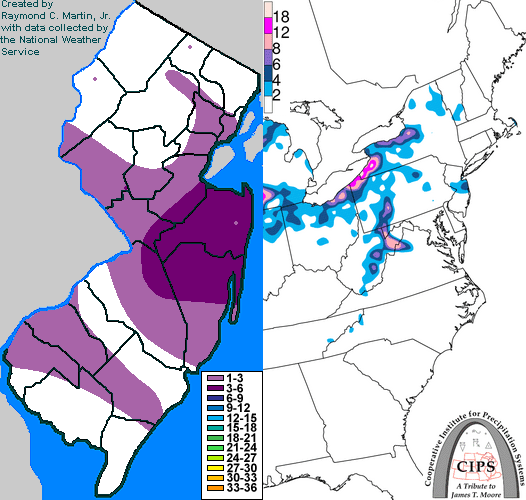
Contoured Snowfall Totals from January 28-29, 2007
STORM DESCRIPTION
A passing upper-level disturbance caused a new surface storm system to develop along a front off the New Jersey coast, bringing the first widespread snowfall of the winter to much of the state, particularly central portions of the state.
Synoptic Discussion
A cold front pushed southeast across the region during the day on Sunday the 28th. An upper-level disturbance trailing behind the front caused a low pressure to develop along the front during the evening of the 28th and early morning of the 29th. By midday on the 29th, the low was well off the coast.
Local Discussion
Light snow gradually overspread the state during the late afternoon and evening hours of the 28th. As the upper-level disturbance approached from the west and a new low pressure developed just off the coast, the snow intensified late in the evening. The heaviest bands of snow developed and presisted across central portions of the state near and after midnight on the 29th. By dawn on the 29th, precipitation had departed off the coast as the new low pressure moved away and the upper-level disturbance passed to the east. Accumulations were highest across Monmouth County where they ranged from 3 to 5 inches. 2 to 4 inches fell across Mercer County, 1 to 3 inches across Ocean, Burlington, Middlesex, Hunterdon, Essex, Union, Gloucester and Salem counties, and a coating to 2 inches fell across the remainder of the state.
New Jersey Snowfall Totals
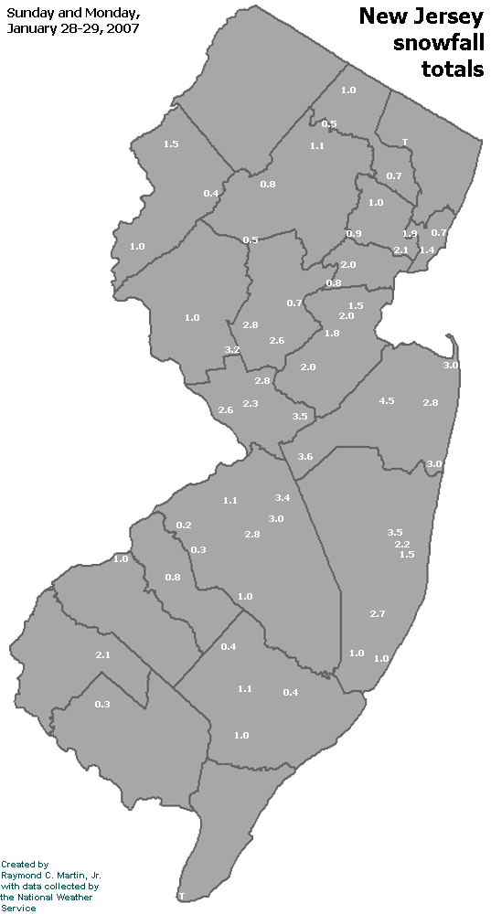
Individual Snowfall Totals from January 28-29, 2007
Table of Contents
Storm Summary
Regional Surface Observations
National Weather Service Forecasts
Surface Maps
Satellite Imagery
National Surface Weather Maps - Pressure and Fronts Only
Continental Surface Weather Maps - Pressure and Fronts Only
Sea Level Pressure and 1000 to 500 Millibar Thickness Maps
850 Millibar Maps
700 Millibar Maps
500 Millibar Maps
300 Millibar Maps
200 Millibar Maps
National Radar Imagery
Regional Radar Imagery
Fort Dix Doppler Radar Imagery
Storm Photos
Snow storm, January 28-29, 2007
Snow and ice storm, February 13-14, 2007
Snow and ice storm, February 25-26, 2007
Snow storm, March 7, 2007
Ice storm, March 15-17, 2007
Back to Ray's Winter Storm Archive
Copyright © 2012 by Raymond C Martin Jr. All rights reserved