

Storm description, surface observations, snowfall totals, and images courtesy of the National Climatic Data Center, the National Centers of Environmental Prediction, the Climate Prediction Center, the Hydrometeorological Prediction Center, the Mount Holly National Weather Service Office, the Upton National Weather Service Office, Rutgers University, Plymouth State University, the University of Illinois, the American Meteorological Society, Weather Graphics Technologies, AccuWeather, and the Weather Channel.
Table of Contents
Storm Summary
Regional Surface Observations
National Weather Service Forecasts
Surface Maps
Satellite Imagery
National Surface Weather Maps - Pressure and Fronts Only
Continental Surface Weather Maps - Pressure and Fronts Only
Sea Level Pressure and 1000 to 500 Millibar Thickness Maps
850 Millibar Maps
700 Millibar Maps
500 Millibar Maps
300 Millibar Maps
200 Millibar Maps
National Radar Imagery
Regional Radar Imagery
Fort Dix Doppler Radar Imagery
Storm Photos
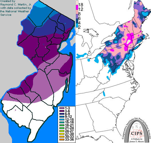
Contoured Snowfall Totals from March 15-17, 2007
STORM DESCRIPTION
A complex winter storm brought heavy snow and sleet to northern New Jersey and one of the heaviest accumulations of sleet on record to central New Jersey. Lesser amounts of sleet fell across southern New Jersey.
Synoptic Discussion
A cold front pushed southeastward across New Jersey during the day on Thursday, March 15th. The front then stalled off the coast as a storm system developed along the front across the Southeastern United States. The storm system moved northeastward along the stalled front, passing the state near midnight on Saturday, March 17th. By 7AM the next morning, the storm was entering the Canadian Maritimes.
Local Discussion
Overrunning moisture caused rain to break out behind the cold front during the late afternoon and early evening of Thursday, March 15th. As cold air continued to push southward behind the front, the rain changed to sleet and snow across central and northern New Jersey late Thursday night and early Friday morning. As the developing storm system to the south moved northeastward along the front, precipitation became heavy at times during the midday and afternoon hours of Friday the 16th. Across southern New Jersey, precipitation was mainly in the form of rain and sleet as the warmer air aloft remained in place while low-level temperatures barely cooled to the freezing mark. Across central New Jersey, the predominant precipitation form was sleet as warmer air lingered aloft but cold air dominated at the surface. Meanwhile, a mixture of snow and sleet fell across northern New Jersey as the warmer air aloft was scoured out at times and cold air dominated at the surface. As the center of the storm moved past the state near midnight on Saturday the 17th, precipitation tapered off from southwest to northeast. Accumulations of snow and sleet ranged from 9 to 14 inches in Sussex County, 5 to 10 inches in Passaic and Morris counties, and 3 to 9 inches in Warren, Essex, Hudson and Bergen counties. Accumulations of mainly sleet ranged from 3 to 6 inches across Hunterdon, Somerset, Union, Middlesex and Mercer counties. Further south, sleet accumulations of 1 to 4 inches fell across Monmouth, Ocean, Burlington, Camden and Gloucester counties. An inch or less of sleet fell across Salem, Atlantic, Cumberland and Cape May counties.
New Jersey Snowfall Totals
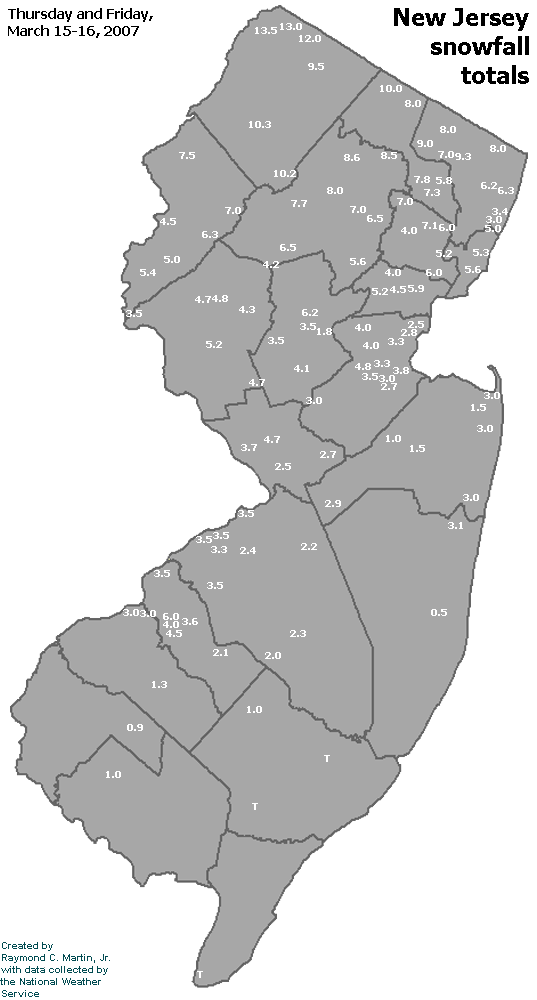
Individual Snowfall Totals from March 15-17, 2007
Table of Contents
Storm Summary
Regional Surface Observations
National Weather Service Forecasts
Surface Maps
Satellite Imagery
National Surface Weather Maps - Pressure and Fronts Only
Continental Surface Weather Maps - Pressure and Fronts Only
Sea Level Pressure and 1000 to 500 Millibar Thickness Maps
850 Millibar Maps
700 Millibar Maps
500 Millibar Maps
300 Millibar Maps
200 Millibar Maps
National Radar Imagery
Regional Radar Imagery
Fort Dix Doppler Radar Imagery
Storm Photos
Snow storm, January 28-29, 2007
Snow and ice storm, February 13-14, 2007
Snow and ice storm, February 25-26, 2007
Snow storm, March 7, 2007
Ice storm, March 15-17, 2007
Back to Ray's Winter Storm Archive
Copyright © 2012 by Raymond C Martin Jr. All rights reserved