

Storm description, surface observations, snowfall totals, and images courtesy of the National Climatic Data Center, the National Centers of Environmental Prediction, the Climate Prediction Center, the Hydrometeorological Prediction Center, the Mount Holly National Weather Service Office, the Upton National Weather Service Office, Rutgers University, Plymouth State University, the University of Illinois, the American Meteorological Society, Weather Graphics Technologies, AccuWeather, and the Weather Channel.
Table of Contents
Storm Summary
Regional Surface Observations
National Weather Service Forecasts
Surface Maps
Satellite Imagery
National Surface Weather Maps - Pressure and Fronts Only
Continental Surface Weather Maps - Pressure and Fronts Only
Sea Level Pressure and 1000 to 500 Millibar Thickness Maps
850 Millibar Maps
700 Millibar Maps
500 Millibar Maps
300 Millibar Maps
200 Millibar Maps
National Radar Imagery
Regional Radar Imagery
Fort Dix Doppler Radar Imagery
Storm Photos
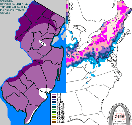
Contoured Snowfall Totals from February 13-14, 2007
STORM DESCRIPTION
An intense and complex storm system from the southern Plains brought a mix of snow, sleet, freezing rain and rain to New Jersey.
Synoptic Discussion
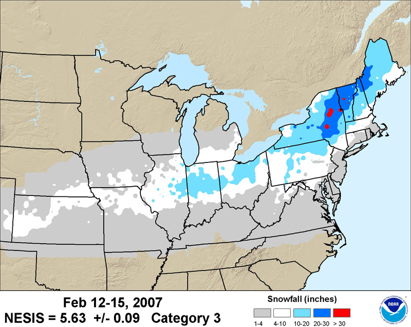
Low pressure developed in the southern Plains on Monday the 12th as a cold front pushed southward across the Northeast. By Tuesday the 13th, the storm moved eastward across the lower Mississippi Valley while the cold front became stationary in the Carolinas. On the night of the 13th, the primary low moved into the far eastern Ohio Valley while a secondary low developed on the stalled front in the Carolinas. During the day on Wednesday the 14th, this secondary low strengthened rapidly and moved northeastward along the mid-Atlantic and New England coasts while the primary low dissipated in the central Appalachians. By Thursday the 15th, the storm had moved into eastern Canada.
Local Discussion
Light to moderate snow overspread the southern half of New Jersey from west to east during the morning of the 13th. Exceptionally dry air across northern New Jersey initially prevented precipitation from spreading any further north. Finally, snow overspread northern areas during the evening of the 13th. At the same time, warm air began moving in aloft, causing the snow to mix with and change to sleet across much of the state by midnight on the 14th. As the secondary low developed and moved northeastward toward the state during the early morning hours of the 14th, sleet and freezing rain became moderate to heavy across much of the state. Warmer air from the ocean also caused the sleet and freezing rain to change to rain across the southeastern quarter of the state, particularly along coastal areas. As the low moved past the state during the afternoon of the 14th, precipitation tapered off from south to north. Accumulations of snow and sleet ranged from a coating to 3 inches across a majority of the state. Exceptions occurred near the lower Delaware River, where 3 to 4 inches accumulated, and across the northwestern fifth of the state, where accumulations ranged from 4 to 8 inches.
New Jersey Snowfall Totals
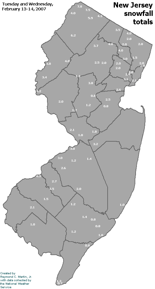
Individual Snowfall Totals from February 13-14, 2007
Regional Snowfall Totals from February 13-14, 2007
Table of Contents
Storm Summary
Regional Surface Observations
National Weather Service Forecasts
Surface Maps
Satellite Imagery
National Surface Weather Maps - Pressure and Fronts Only
Continental Surface Weather Maps - Pressure and Fronts Only
Sea Level Pressure and 1000 to 500 Millibar Thickness Maps
850 Millibar Maps
700 Millibar Maps
500 Millibar Maps
300 Millibar Maps
200 Millibar Maps
National Radar Imagery
Regional Radar Imagery
Fort Dix Doppler Radar Imagery
Storm Photos
Snow storm, January 28-29, 2007
Snow and ice storm, February 13-14, 2007
Snow and ice storm, February 25-26, 2007
Snow storm, March 7, 2007
Ice storm, March 15-17, 2007
Back to Ray's Winter Storm Archive
Copyright © 2012 by Raymond C Martin Jr. All rights reserved