

Storm description, surface observations, snowfall totals, and images courtesy of the National Climatic Data Center, the National Centers of Environmental Prediction, the Climate Prediction Center, the Hydrometeorological Prediction Center, the Mount Holly National Weather Service Office, the Upton National Weather Service Office, Rutgers University, Plymouth State University, the University of Illinois, the American Meteorological Society, Weather Graphics Technologies, AccuWeather, and the Weather Channel.
Table of Contents
Storm Summary
Regional Surface Observations
National Weather Service Forecasts
Surface Maps
Satellite Imagery
National Surface Weather Maps - Pressure and Fronts Only
Continental Surface Weather Maps - Pressure and Fronts Only
Sea Level Pressure and 1000 to 500 Millibar Thickness Maps
850 Millibar Maps
700 Millibar Maps
500 Millibar Maps
300 Millibar Maps
200 Millibar Maps
National Radar Imagery
Regional Radar Imagery
Fort Dix Doppler Radar Imagery
Contoured Snowfall Totals from February 9-11, 2010
STORM DESCRIPTION
The second strong nor'easter in less than a week brought the third major snowfall of the winter to New Jersey, along with another round of near-blizzard conditions. Unlike the storm's predecessor, this storm significantly affected the entire state.
Synoptic Discussion
This storm had two major components which combined to result in a rapidly strengthening nor'easter once it reached the Mid Atlantic coast. The first component was a Pacific storm system which moved across California and into Nevada during the day on February 6th. During the day on the 7th, this system crossed the Four Corners region, and during the day on the 8th it crossed Texas. Meanwhile, the second component moved due south from Canada into Minnesota during the day on the 7th, and entered Iowa on the 8th. By the morning of the 9th, the Pacific or "southern stream" system had moved into the lower Mississippi Valley, while the Canadian or "northern stream" system was in Illinois. Upper level energy from the two systems began to merge during the day on the 9th, and by evening of the 9th one low pressure was located in Ohio while a second was developing along the Carolina coast. By the morning of the 10th, the northern low had moved into Pennsylvania while the southern low was along the Maryland coast. During the day on the 10th, the two lows consolidated just east of New Jersey, with the consolidated low rapidly strengthening by the evening. The low moved eastward away from the mainland during the night of the 10th and was well off the coast by the morning of the 11th.
Local Discussion
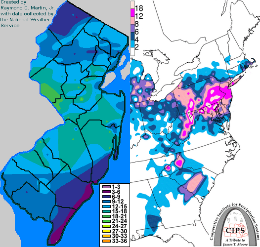
Precipitation overspread the state from west to east during the early evening of February 9th. It began as snow in most areas, but was mixed with sleet, freezing rain and rain in far southern New Jersey. During the remainder of the evening and overnight hours, the heaviest precipitation fell in southern and central New Jersey, with much lighter precipitation in the north. In addition, warm air slowly spread northward both aloft and at the surface, causing the snow to mix with and change to a mixture sleet, freezing rain and rain as far north as the US Route 1 corridor in central New Jersey. Precipitation lightened in intensity during the morning of the 10th, while remaining all snow in the north and a mixture of sleet, freezing rain and rain in central and southern New Jersey. As the low started to strengthen rapidly during the midday hours, cold air moved back across central and southern New Jersey with heavy snow developing statewide. Heavy snow persisted longest across central New Jersey, with lighter snow but gustier winds resulting in blizzard conditions across parts of southern New Jersey during the late afternoon. Snow began to taper off from west to east during the evening of the 10th, with all snow ending during the overnight hours. Accumulations were more evenly dispersed across the state as compared to this storm's immediate predecessor, but were heaviest across central New Jersey and significantly lighter in both the far north and far south. Totals ranged from 11 to 21 inches in Middlesex and Somerset counties, 10 to 20 inches in Camden, Hunterdon, Mercer, Monmouth and Union counties, 6 to 18 inches in Bergen, Burlington, Cumberland, Essex, Gloucester, Hudson, Hunterdon, Morris, Ocean, Passaic, Salem and Sussex counties, 4 to 18 inches in Atlantic County, and 1 to 9 inches in Cape May County.
New Jersey Snowfall Totals
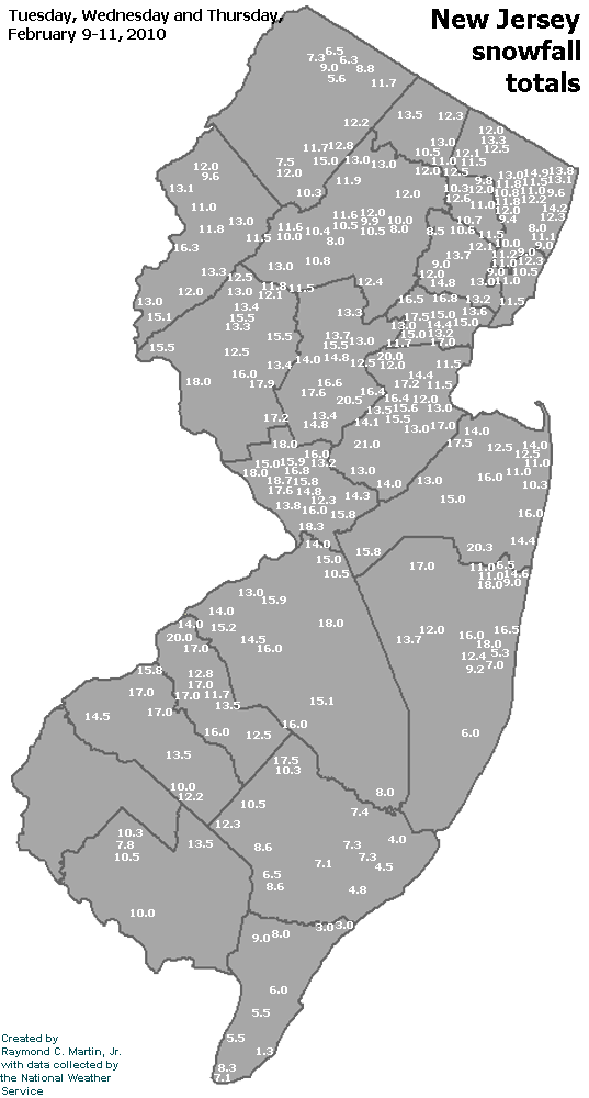
Individual Snowfall Totals from February 9-11, 2010
Regional Snowfall Totals
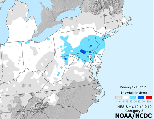
Snowfall Totals from February 9-11, 2010
Table of Contents
Storm Summary
Regional Surface Observations
National Weather Service Forecasts
Surface Maps
Satellite Imagery
National Surface Weather Maps - Pressure and Fronts Only
Continental Surface Weather Maps - Pressure and Fronts Only
Sea Level Pressure and 1000 to 500 Millibar Thickness Maps
850 Millibar Maps
700 Millibar Maps
500 Millibar Maps
300 Millibar Maps
200 Millibar Maps
National Radar Imagery
Regional Radar Imagery
Fort Dix Doppler Radar Imagery
Snow storm, December 5, 2009
Snow storm, December 19-20, 2009
Snow storm, December 31, 2009
Snow storm, February 2-3, 2010
Snow storm, February 5-6, 2010
Snow storm, February 9-11, 2010
Snow storm, February 15-16, 2010
Snow storm, February 25-26, 2010
Back to Ray's Winter Storm Archive
Copyright © 2012 by Raymond C Martin Jr. All rights reserved