

Storm description, surface observations, snowfall totals, and images courtesy of the National Climatic Data Center, the National Centers of Environmental Prediction, the Climate Prediction Center, the Hydrometeorological Prediction Center, the Mount Holly National Weather Service Office, the Upton National Weather Service Office, Rutgers University, Plymouth State University, the University of Illinois, the American Meteorological Society, Weather Graphics Technologies, AccuWeather, and the Weather Channel.
Table of Contents
Storm Summary
Regional Surface Observations
National Weather Service Forecasts
Surface Maps
Satellite Imagery
National Surface Weather Maps - Pressure and Fronts Only
Continental Surface Weather Maps - Pressure and Fronts Only
Sea Level Pressure and 1000 to 500 Millibar Thickness Maps
850 Millibar Maps
700 Millibar Maps
500 Millibar Maps
300 Millibar Maps
200 Millibar Maps
National Radar Imagery
Regional Radar Imagery
Fort Dix Doppler Radar Imagery
Contoured Snowfall Totals from December 19-20, 2009
STORM DESCRIPTION
A strong nor'easter brought a major snowfall to most of New Jersey, along with near-blizzard conditions.
Synoptic Discussion
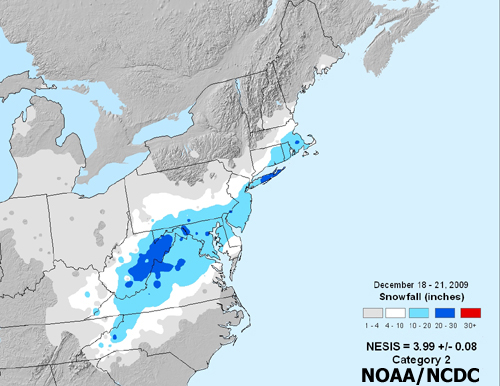
A cold front swept across New Jersey on the morning of December 15th. The trailing end of the front stalled in the Gulf of Mexico, where a low pressure system began developing during the night of December 15th. The low remained stationary in the far western Gulf of Mexico until 17th, when it began to move east-northeast and started to intensify. At the same time, a reinforcing cold front moved across New Jersey, allowing a strong area of arctic high pressure to build across the state. The low reached the north-central Gulf coast on the morning of the 18th. At the same time, another weak low pressure system was moving slowly eastward across the central Plains. By the evening of the 18th, the low from the Gulf reached the Georgia coast and the low from the Plains was in the mid Mississippi Valley. This second low subsequently transferred its energy to the low along the Georgia coast, which continued to intensify and reached the Outer Banks of North Carolina on the morning of the 19th. By the evening of the 19th, this low had continued to intensify and was now due east of Maryland. The low continued to intensify as it moved to a position southeast of Cape Cod by the morning of the 20th. By the evening of the 20th, it was just southeast of Nova Scotia.
Local Discussion
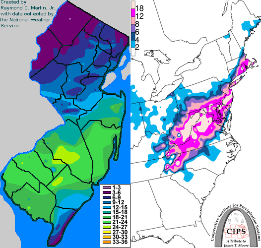
Precipitation overspread southern New Jersey during the predawn hours of December 19th, and quickly became heavy at times. It started as snow nearly everywhere, except in parts of Cape May County where it was a mixture of rain and snow. Further north, dry air from the arctic high pressure remained dominant for quite a while. Snow reached central New Jersey around dawn, but had great difficulty proceeding any further north. In fact, for a time during the midday hours on the 19th, dry air actually advanced back toward the south, interrupting the snow in areas where it had already begun. Snow finally spread back across central New Jersey during the early afternoon of the 19th, and overspread northern New Jersey during the mid afternoon hours. Meanwhile, heavy snow continued across much of southern New Jersey through most of the day on the 19th. Heavy snow gradually spread northeastward into the eastern parts of Central New Jersey during the late afternoon and evening hours on the 19th, while slowly starting to diminish across southwestern New Jersey. Heavy snow finally ended near midnight on the 20th across all of New Jersey, but light snow lingered through the overnight hours and into the early morning of December 20th before finally tapering off after dawn. Accumulations were heaviest across most of southern and east-central New Jersey, with lighter amounts in the far south, west-central and northern portions of the state. Totals ranged from 19 to 25 inches in Gloucester and Salem counties, 14 to 25 inches in Burlington and Camden counties, 11 to 25 inches in Atlantic and Monmouth counties, 16 to 24 inches in Cumberland and Ocean counties, 2 to 18 inches in Cape May County, 6 to 16 inches in Essex, Hunterdon, Mercer, Middlesex and Somerset counties, 4 to 13 inches in Bergen, Hudson, Morris, Passaic and Union counties, and 2 to 8 inches in Sussex and Warren counties.
New Jersey Snowfall Totals
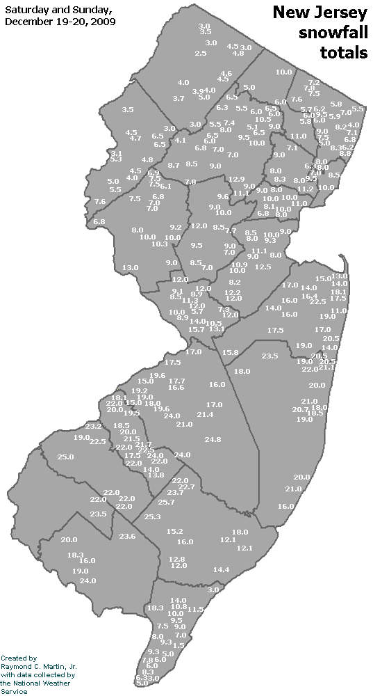
Individual Snowfall Totals from December 19-20, 2009
Regional Snowfall Totals
Snowfall Totals from December 19-20, 2009
Table of Contents
Storm Summary
Regional Surface Observations
National Weather Service Forecasts
Surface Maps
Satellite Imagery
National Surface Weather Maps - Pressure and Fronts Only
Continental Surface Weather Maps - Pressure and Fronts Only
Sea Level Pressure and 1000 to 500 Millibar Thickness Maps
850 Millibar Maps
700 Millibar Maps
500 Millibar Maps
300 Millibar Maps
200 Millibar Maps
National Radar Imagery
Regional Radar Imagery
Fort Dix Doppler Radar Imagery
Snow storm, December 5, 2009
Snow storm, December 19-20, 2009
Snow storm, December 31, 2009
Snow storm, February 2-3, 2010
Snow storm, February 5-6, 2010
Snow storm, February 9-11, 2010
Snow storm, February 15-16, 2010
Snow storm, February 25-26, 2010
Back to Ray's Winter Storm Archive
Copyright © 2012 by Raymond C Martin Jr. All rights reserved