

Storm description, surface observations, snowfall totals, and images courtesy of the National Climatic Data Center, the National Centers of Environmental Prediction, the Climate Prediction Center, the Hydrometeorological Prediction Center, the Mount Holly National Weather Service Office, the Upton National Weather Service Office, Rutgers University, Plymouth State University, the University of Illinois, the American Meteorological Society, Weather Graphics Technologies, AccuWeather, and the Weather Channel.
Table of Contents
Storm Summary
Regional Surface Observations
National Weather Service Forecasts
Surface Maps
Satellite Imagery
National Surface Weather Maps - Pressure and Fronts Only
Continental Surface Weather Maps - Pressure and Fronts Only
Sea Level Pressure and 1000 to 500 Millibar Thickness Maps
850 Millibar Maps
700 Millibar Maps
500 Millibar Maps
300 Millibar Maps
200 Millibar Maps
National Radar Imagery
Regional Radar Imagery
Fort Dix Doppler Radar Imagery
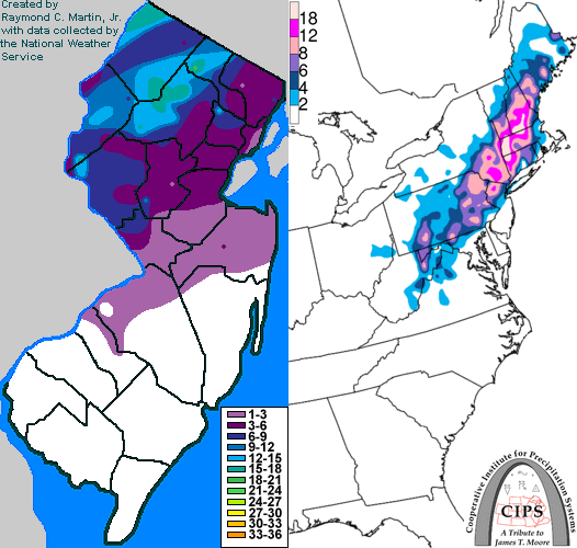
Contoured Snowfall Totals from October 29-30, 2011
STORM DESCRIPTION
An early season nor'easter combined with an unusually cold high pressure system to bring a record-setting October snowstorm to much of New Jersey. In some areas, more snow fell during this storm than fell during the entire rest of the winter, while for many areas this was the largest snowfall of the winter.
Synoptic Discussion
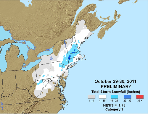
An unusually strong cold front moved across New Jersey on October 27th, allowing an unseasonably strong and cold high pressure system to move into the Northeast on the 28th. At the same time, a wave of low pressure began developing as the tail end of the front stalled out in Texas on the 27th, and migrated into the Southeast on the 28th. Energy began to transfer to a new low pressure system developing along the Carolina coast on the night of the 28th. This new low pressure then began to move northeast up the East Coast on the 29th, strengthening as it did so. By the pre-dawn hours of the 30th, the storm had deepened to 985 millibars and was located near Cape Cod. The low departed the region and passed near Nova Scotia during the day on the 30th.
Local Discussion
Precipitation began overspreading the state from southwest to northeast during the early morning hours on October 29th. While temperatures were already cold enough for snow aloft, warm air near the ground caused precipitation to start out as rain in all portions of the state except the far northwest. As precipitation became heavier, the melting snow aloft began to cause the low levels to cool, and the rain changed to moderate to heavy snow across northern, central and southwestern New Jersey during the mid to late morning. Precipitation generally remained in the form of snow throughout the storm across northern New Jersey, but as warm air began to move in at mid-levels of the atmosphere, the snow mixed with sleet and rain again during the afternoon of the 29th across central and southwestern New Jersey. As the low pressure began pulling away to the northeast during the evening of the 29th, cold air wrapped back around the low and down across New Jersey, and the rain and sleet changed back to snow in central and southwestern New Jersey, while mixing with sleet and snow in southeastern New Jersey. Precipitation ended from west to east during the late evening hours on the 29th and the early morning hours on the 30th. Snowfall totals, particularly in west-central and northern New Jersey, were unprecedented for any storm during the month of October since records began in the mid to late 1800s. Accumulations were elevation-dependent, meaning that large variations occurred over short distances due to relatively minor changes in height above sea level. Massive amounts of tree and power line damage occurred in central and particularly northern New Jersey as the heavy wet snow combined with foliage which remained on many deciduous trees, and some areas went more than a week before power was restored. Accumulations ranged from 5 to 19 inches in Passaic County, 6 to 17 inches in Sussex County, 4 to 17 inches in Morris County, 5 to 16 inches in Warren County, 3 to 13 inches in Hunterdon County, 4 to 12 inches in Essex County, 3 to 10 inches in Somerset County, 2 to 8 inches in Bergen County, 1 to 7 inches in Mercer County, 2 to 6 inches in Middlesex County, 4 to 5 inches in Union County, 2 to 4 inches in Hudson County, a coating to 3 inches in Monmouth County, a coating to 2 inches in Burlington County, a coating to 1 inch in Ocean and Camden counties, and a coating or less in Gloucester, Salem, Cumberland, Atlantic and Cape May counties.
New Jersey Snowfall Totals
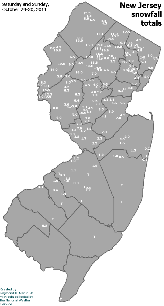
Individual Snowfall Totals from October 29-30, 2011
Regional Snowfall Totals
Snowfall Totals from October 29-30, 2011
Table of Contents
Storm Summary
Regional Surface Observations
National Weather Service Forecasts
Surface Maps
Satellite Imagery
National Surface Weather Maps - Pressure and Fronts Only
Continental Surface Weather Maps - Pressure and Fronts Only
Sea Level Pressure and 1000 to 500 Millibar Thickness Maps
850 Millibar Maps
700 Millibar Maps
500 Millibar Maps
300 Millibar Maps
200 Millibar Maps
National Radar Imagery
Regional Radar Imagery
Fort Dix Doppler Radar Imagery
Snow storm, October 29-30, 2011
Snow and ice storm, January 21, 2012
Snow storm, February 8, 2012
Snow storm, February 10-11, 2012
Snow storm, February 11-12, 2012
Back to Ray's Winter Storm Archive
Copyright © 2012 by Raymond C Martin Jr. All rights reserved