

Storm description, surface observations, snowfall totals, and images courtesy of the National Climatic Data Center, the National Centers of Environmental Prediction, the Climate Prediction Center, the Hydrometeorological Prediction Center, the Mount Holly National Weather Service Office, the Upton National Weather Service Office, Rutgers University, Plymouth State University, the University of Illinois, the American Meteorological Society, Weather Graphics Technologies, AccuWeather, and the Weather Channel.
Table of Contents
Storm Summary
Regional Surface Observations
National Weather Service Forecasts
Surface Maps
Satellite Imagery
National Surface Weather Maps - Pressure and Fronts Only
Continental Surface Weather Maps - Pressure and Fronts Only
Sea Level Pressure and 1000 to 500 Millibar Thickness Maps
850 Millibar Maps
700 Millibar Maps
500 Millibar Maps
300 Millibar Maps
200 Millibar Maps
National Radar Imagery
Regional Radar Imagery
Fort Dix Doppler Radar Imagery
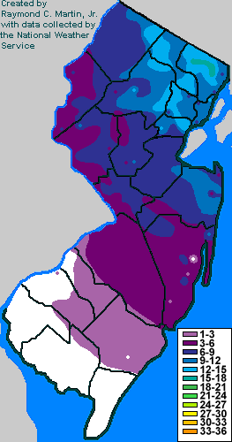
Contoured Snowfall Totals from February 8-9, 2013
STORM DESCRIPTION
A rapidly strengthening nor'easter brought heavy snow to northeastern New Jersey, with lesser amounts further south and west. Very little snow fell in far southwestern New Jersey.
Synoptic Discussion
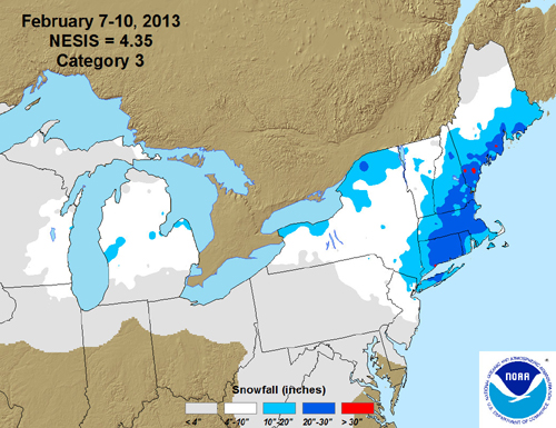
A cold front crossed New Jersey during the day on February 6th, ushering in a fresh batch of cold Canadian air with it. At the same time, a low pressure system started to develop along the Texas Gulf coast, while another low pressure entered the northern Plains from southern Canada. Both low pressure systems moved eastward, with the southern low reaching the Florida panhandle and the northern low reaching Iowa by the midday hours on the 7th. By the early morning on the 8th, the southern low had reached the coast of South Carolina, while the northern low was in Ohio. By the midday hours on the 8th, the southern low had turned north, rapidly intensified, and was due east of Virginia Beach, while the northern low was in northwestern Pennsylvania and was starting to get absorbed by the southern low. By the early morning hours of the 9th, the northern low had been completely absorbed by the southern low, which was now extremely powerful and was located just southeast of Cape Cod. From here, the consolidated low pressure moved very slowly, finally reaching Nova Scotia late on the 9th.
Local Discussion
Precipitation from the southern low pressure system overspread New Jersey from southwest to northeast during the morning hours on February 8th. Over southern New Jersey, precipitation was mainly in the form of rain, while it mixed with sleet and snow in central New Jersey and turned entirely to sleet and snow over the northern third of the state. In northern New Jersey, some of the snow was heavy at times, but relatively mild temperatures kept accumulations relatively modest at first. Precipitation from the southern system slowly exited from west to east during the late afternoon and early evening on the 8th, but precipitation moving in with the northern low pressure caught up to it and enveloped the state during the mid to late evening on the 8th. By this time, cold air had wrapped southward around the strenthening southern system and precipitation was mainly in the form of snow state-wide. Bands of moderate to heavy snow fell across parts of northern and central New Jersey, while lighter snow fell in the southern portion of the state. Snow gradually dissipated and retreated from west to east during the early morning hours on the 9th. Total snowfall was highest in northeastern New Jersey which benefited most from both rounds of snowfall, with totals decreasing to the south and west. Very little snow fell in far southwestern New Jersey, where the first round of precipitation was rain and the second round was very light. Totals ranged from 8 to 16 inches in Bergen, Union and Essex counties, 5 to 14 inches in Sussex, Morris, Passaic and Hudson counties, 4 to 11 inches in Monmouth, Middlesex and Somerset counties, 3 to 9 inches in Ocean, Warren, Hunterdon and Mercer counties, 2 to 6 inches in Burlington County, 1 to 2 inches in Atlantic, Camden and Gloucester counties, a coating to 2 inches in Cumberland County and less than an inch in Salem and Cape May counties.
New Jersey Snowfall Totals
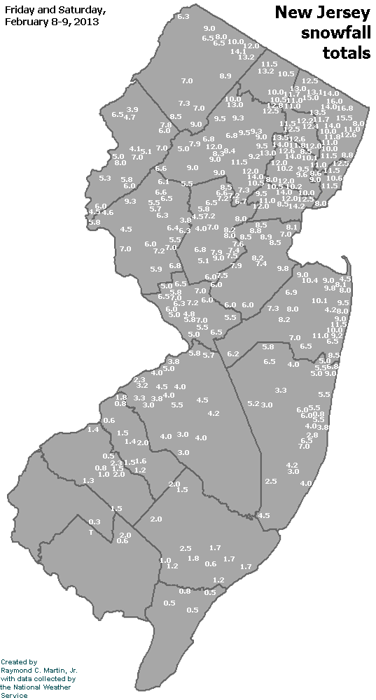
Individual Snowfall Totals from February 8-9, 2013
Regional Snowfall Totals
Snowfall Totals from February 8-9, 2013
Table of Contents
Storm Summary
Regional Surface Observations
National Weather Service Forecasts
Surface Maps
Satellite Imagery
National Surface Weather Maps - Pressure and Fronts Only
Continental Surface Weather Maps - Pressure and Fronts Only
Sea Level Pressure and 1000 to 500 Millibar Thickness Maps
850 Millibar Maps
700 Millibar Maps
500 Millibar Maps
300 Millibar Maps
200 Millibar Maps
National Radar Imagery
Regional Radar Imagery
Fort Dix Doppler Radar Imagery
Snow storm, November 7-8, 2012
Snow and ice storm, December 29, 2012
Snow storm, January 25, 2013
Snow and ice storm, February 8-9, 2013
Snow storm, March 7-8, 2013
Snow storm, March 16, 2013
Back to Ray's Winter Storm Archive
Copyright © 2014 by Raymond C Martin Jr. All rights reserved