

Storm description, surface observations, snowfall totals, and images courtesy of the National Climatic Data Center, the National Centers of Environmental Prediction, the Climate Prediction Center, the Hydrometeorological Prediction Center, the Mount Holly National Weather Service Office, the Upton National Weather Service Office, Rutgers University, Plymouth State University, the University of Illinois, the American Meteorological Society, Weather Graphics Technologies, AccuWeather, and the Weather Channel.
Table of Contents
Storm Summary
Regional Surface Observations
National Weather Service Forecasts
Surface Maps
Satellite Imagery
Sea Level Pressure and 1000 to 500 Millibar Thickness Maps
850 Millibar Maps
700 Millibar Maps
500 Millibar Maps
300 Millibar Maps
200 Millibar Maps
National Radar Imagery
Local Radar Imagery
Fort Dix Doppler Radar Imagery
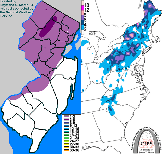
Contoured Snowfall Totals from February 14, 1997
STORM DESCRIPTION
A low pressure system travelling north along the Eastern Seaboard brought a mixture of snow and freezing rain across New Jersey during the morning of the 14th.
Synoptic Discussion
A high pressure system brought a relatively cold and dry airmass to the northeast during the 12th and 13th. Meanwhile, a low pressure developed over northern Mexico on the 12th. It moved along the southern parts of the Gulf Coast states on the 13th before moving quickly up the east coast between the night of the 13th to the night of the 14th. The low travelled from Savannah, Georgia at 7pm EST on the 13th to Portland, Maine at 7pm EST on the 14th.
Local Discussion
Snow overspread the state between midnight and 3am EST on the 14th. Over southeastern sections it quickly changed to rain by 4am EST. From the southwestern and east central sections northward, warmer air at mid-levels outraced warmer ocean air at the surface, causing the snow to change to a brief period of freezing rain between 4am EST and 7am EST in southwestern, central and northeastern sections, and to change to what would be a longer period of freezing rain around dawn in northwestern sections. East winds brought milder ocean air into southwestern, central, and northeastern sections during the morning rush hour, causing the freezing rain to change to rain in all areas by 9am EST. However, colder air remained trapped in the northwestern valleys and prevented a change to rain until around noon, when the precipitation tapered off. Snowfall totals were light due to the fast movement of the storm, with around 1 inch in northeastern, central, and southwestern sections, and 2 to 3 inches in northwestern sections. Up to a quarter of an inch of ice also accrued in northwestern valleys.
New Jersey Snowfall Totals
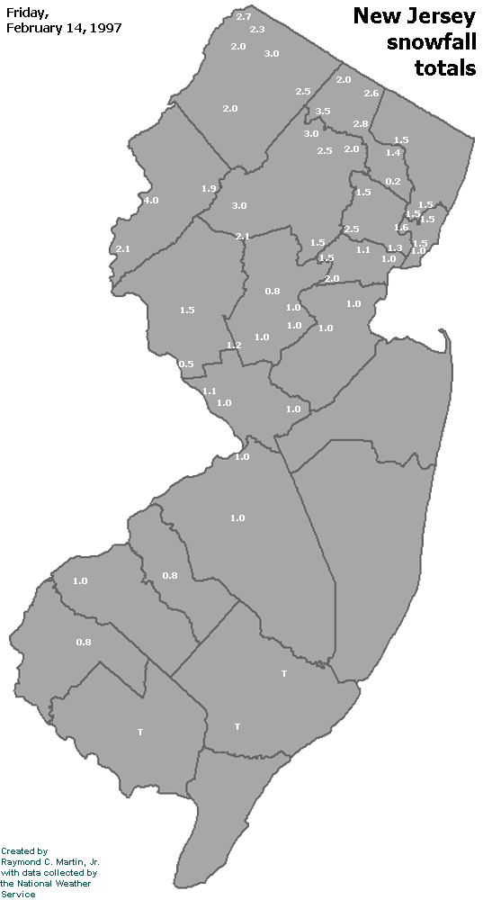
Individual Snowfall Totals from February 14, 1997
Table of Contents
Storm Summary
Regional Surface Observations
National Weather Service Forecasts
Surface Maps
Satellite Imagery
Sea Level Pressure and 1000 to 500 Millibar Thickness Maps
850 Millibar Maps
700 Millibar Maps
500 Millibar Maps
300 Millibar Maps
200 Millibar Maps
National Radar Imagery
Local Radar Imagery
Fort Dix Doppler Radar Imagery
Snow and ice storm, January 9, 1997
Snow storm, January 11, 1997
Snow storm, February 8-9, 1997
Snow storm, February 14, 1997
Snow storm, March 3, 1997
Snow and ice storm, March 9-10, 1997
Snow storm, March 31-April 1, 1997
Snow storm, April 18, 1997
Back to Ray's Winter Storm Archive
Copyright © 2012 by Raymond C Martin Jr. All rights reserved