

Storm description, surface observations, snowfall totals, and images courtesy of the National Climatic Data Center, the National Centers of Environmental Prediction, the Climate Prediction Center, the Hydrometeorological Prediction Center, the Mount Holly National Weather Service Office, the Upton National Weather Service Office, Rutgers University, Plymouth State University, the University of Illinois, the American Meteorological Society, Weather Graphics Technologies, AccuWeather, and the Weather Channel.
Table of Contents
Storm Summary
Regional Surface Observations
Satellite Imagery
National Surface Weather Maps - Pressure and Fronts Only
Sea Level Pressure and 1000 to 500 Millibar Thickness Maps
850 Millibar Maps
700 Millibar Maps
500 Millibar Maps
300 Millibar Maps
200 Millibar Maps
National Radar Imagery
Fort Dix Doppler Radar Imagery
Contoured Snowfall Totals from April 09, 2000
STORM DESCRIPTION
A strong Spring cold front and developing wave of low pressure combined to produce a sudden Spring snow fall across most of New Jersey.
Synoptic Discussion
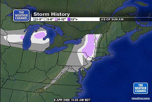
A strong cold front passed over the East Coast on the evening of the 8th. A strong secondary low formed on the frontal boundary in the Mid Atlantic overnight, and by 8AM EDT on the 9th it had moved north to Worcester, Massachusetts. As the low quickly intensified, it produced a large shield of precipitation behind the cold front, while at the same time pulled the colder air in behind it more quickly with very strong northwest winds. By the evening of the 9th, the low and associated precipitation had pulled northeastward into Canada.
Local Discusion
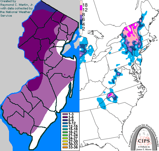
The strong cold front passed through New Jersey on the evening of the 8th between 6PM and 8PM EDT. A squall line just ahead of the front had weakened as it approached the coast and interacted with more stable marine air over the ocean, and as it crossed New Jersey the line only produced some light rain showers. Temperatures fell quickly as the front passed, from the upper 60s and lower 70s down to the mid 50s in just an hour's time. Temperatures continued to fall straight through into the mid morning of the 9th. Post-frontal precipitation associated with the developing secondary low moved into the state as rain between 10PM EDT on the 8th and 2AM EDT on the 9th. As temperatures continued to fall, the rain changed to snow from north to south across western New Jersey, but then southwest to northeast across eastern New Jersey. The change to snow occured around 1AM EDT on the 9th in Sussex County, and proceeded south to Cumberland County by 5AM EDT. It then worked its way back to the northeastern sections, reaching Teterboro by 9AM EDT. The snow became heavy at times for a few hours during the morning of the 9th in many locations. Snow tapered off from southwest to northeast between 10AM EDT and 2PM EDT on the 9th. Accumulations were greatest in the northwestern counties where the changeover had occured earliest and precipitation had fallen for the longest time as snow. 4 to 8 inches fell in Sussex and Warren counties, 2 to 6 inches in Passaic and Morris counties, 3 to 5 inches in Huterdon, Somerset, and Mercer counties, 2 to 4 inches in Middlesex, Monmouth and Burlington counties, and a coating to 3 inches in Camden, Gloucester, Ocean, Union, Essex, Hudson, and Bergen counties. Only a dusting to an inch accumulated in the southern coastal counties of Salem, Cumberland, Cape May, and Atlantic. Winds with this system were also very strong, reaching peak gusts of 65 mph in Harvey Cedars on the coast, and 67 mph at High Point in the far northwest.
New Jersey Snowfall Totals
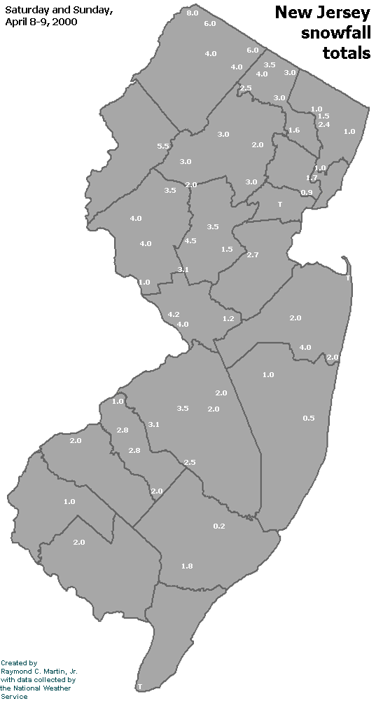
Individual Snowfall Totals from April 09, 2000
Regional Snowfall Totals
Snowfall totals from 1400Z 09 April 2000 (10AM EDT 09 April 2000)
Table of Contents
Storm Summary
Regional Surface Observations
Satellite Imagery
National Surface Weather Maps - Pressure and Fronts Only
Sea Level Pressure and 1000 to 500 Millibar Thickness Maps
850 Millibar Maps
700 Millibar Maps
500 Millibar Maps
300 Millibar Maps
200 Millibar Maps
National Radar Imagery
Fort Dix Doppler Radar Imagery
Snow storm, January 20, 2000
Snow and ice storm, January 25, 2000
Snow and ice storm, January 30-31, 2000
Snow storm, February 3, 2000
Snow and ice storm, February 18-19, 2000
Snow storm, April 9, 2000
Back to Ray's Winter Storm Archive
Copyright © 2012 by Raymond C Martin Jr. All rights reserved