

Storm description, surface observations, snowfall totals, and images courtesy of the National Climatic Data Center, the National Centers of Environmental Prediction, the Climate Prediction Center, the Hydrometeorological Prediction Center, the Mount Holly National Weather Service Office, the Upton National Weather Service Office, Rutgers University, Plymouth State University, the University of Illinois, the American Meteorological Society, Weather Graphics Technologies, AccuWeather, and the Weather Channel.
Table of Contents
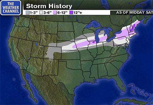
Storm Summary
Regional Surface Observations
National Weather Service Forecasts
Satellite Imagery
National Surface Weather Maps - Pressure and Fronts Only
Sea Level Pressure and 1000 to 500 Millibar Thickness Maps
850 Millibar Maps
700 Millibar Maps
500 Millibar Maps
300 Millibar Maps
200 Millibar Maps
National Radar Imagery
Fort Dix Doppler Radar Imagery
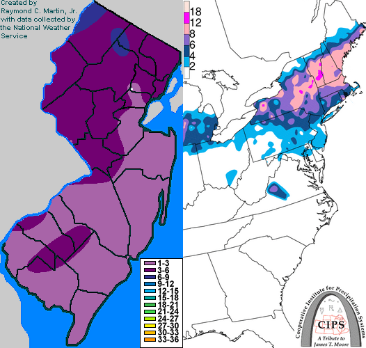
Contoured Snowfall Totals from February 18-19, 2000
STORM DESCRIPTION
A pair of low pressure systems from the southern Plains and southeastern states brought a period of moderate to heavy snow to New Jersey on the morning of the 18th. The snow then changed to rain and freezing rain, giving some areas of west central and northern New Jersey a significant ice acretion.
Synoptic Discussion
A pair of low pressure systems developed during the day on the 17th: one in the southern Plains, and the other off the South Carolina coast. By Friday morning the 18th, one low was over the Outer Banks of North Carolina, while the other lingered back near Springfield, Missouri. At the same time, a large high pressure had moved across the northern Middle Atlantic states and New England, supplying fresh cold air to the region. The lows tracked northeastward and crossed the extreme southeastern section of New Jersey during the night of the 18th and morning of the 19th. Whle the lows were able to funnel warmer Atlantic air inland in southern and east central sections of New Jersey, they were relatively weak and were unable to scour out the cold air in west central and northern sections of the state. Despite their lack of strength, the precipitation lingered across the state for more than 24 hours because there were two low centers instead of just one.
Local Discusion
Snow spread across New Jersey between 6AM EST and 9AM EST on Friday morning the 18th. As warmer air moved in aloft during the middle of the day, the snow changed to sleet and freezing rain between noon and 4PM EST. At the same time, east winds around the low pressures allowed milder Atlantic air to move in at the surface in the flat Coastal Plain of southern and eastern New Jersey, keeping the period of freezing precipitation brief before temperatures rose above freezing. However, the winds were not strong enough to scour the cold air out of the hillier Piedmont and Upland regions of the west central and northern portions of New Jersey. Here freezing rain lingered until the morning of the 19th, when precipitation finally left the state with the second low pressure. Snow accumulations with the first burst of precipitation on the morning of the 18th reached 4 to 6 inches across Sussex, Warren, Morris, Passaic, and Bergen counties. Areas further south saw 2 to 4 inches, except for the immediate coast and Cape May County, where an inch or less accumulated. Ice accretion was negligible across southern and east central New Jersey. However, in northern and west central sections, between two tenths and four tenths of an inch of ice accrued on exposed surfaces by the morning of the 19th.
New Jersey Snowfall Totals
Individual Snowfall Totals from February 18-19, 2000
Regional Snowfall Totals
Snowfall totals from 1600Z 19 February 2000 (11AM EST 19 February 2000)
Table of Contents
Storm Summary
Regional Surface Observations
National Weather Service Forecasts
Satellite Imagery
National Surface Weather Maps - Pressure and Fronts Only
Sea Level Pressure and 1000 to 500 Millibar Thickness Maps
850 Millibar Maps
700 Millibar Maps
500 Millibar Maps
300 Millibar Maps
200 Millibar Maps
National Radar Imagery
Fort Dix Doppler Radar Imagery
Snow storm, January 20, 2000
Snow and ice storm, January 25, 2000
Snow and ice storm, January 30-31, 2000
Snow storm, February 3, 2000
Snow and ice storm, February 18-19, 2000
Snow storm, April 9, 2000
Back to Ray's Winter Storm Archive
Copyright © 2012 by Raymond C Martin Jr. All rights reserved