

Storm description, surface observations, snowfall totals, and images courtesy of the National Climatic Data Center, the National Centers of Environmental Prediction, the Climate Prediction Center, the Hydrometeorological Prediction Center, the Mount Holly National Weather Service Office, the Upton National Weather Service Office, Rutgers University, Plymouth State University, the University of Illinois, the American Meteorological Society, Weather Graphics Technologies, AccuWeather, and the Weather Channel.
Table of Contents
Storm Summary
Regional Surface Observations
National Weather Service Forecasts
Surface Maps
Satellite Imagery
National Surface Weather Maps - Pressure and Fronts Only
Sea Level Pressure and 1000 to 500 Millibar Thickness Maps
850 Millibar Maps
700 Millibar Maps
500 Millibar Maps
300 Millibar Maps
200 Millibar Maps
National Radar Imagery
Local Radar Imagery
Fort Dix Doppler Radar Imagery
Contoured Snowfall Totals from January 30-31, 2000
STORM DESCRIPTION
A quick moving storm brought a burst of snow, sleet, freezing rain, and/or rain to New Jersey.
Synoptic Discussion
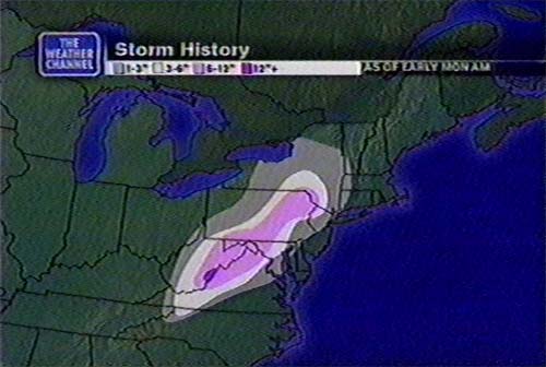
A low pressure developed in the western Gulf of Mexico during the day on the 28th. It moved slowly northeastwards, reaching Apalachicola, Florida on the morning of the 30th. It then started moving rapidly, quickly heading up the coast and reaching Boston, Massachusetts on the morning of the 31st.
Local Discusion
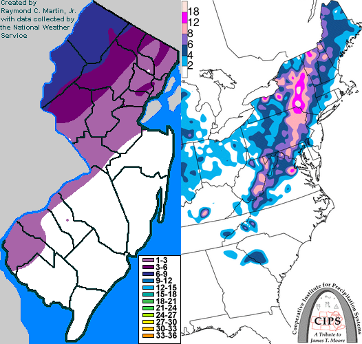
The combination of a low track just inland of the coast, as well as less cold air present initially, allowed for a more typical potpourri of weather across New Jersey during this storm, with primarily rain in far southeastern sections and primarily snow across far northwestern sections. Precipitation overspread the state late in the afternoon of the 30th. It began as snow in most areas, except the far southeast and coastal sections, where enough warm air had moved in from the ocean to allow precipitation to begin only briefly as sleet or freezing rain before quickly changing to rain. By early evening, precipitation had changed to sleet and freezing rain across southwestern sections of the state, but west central and northern sections remained all snow. By 9PM EST, enough warm air had made it inland to change the precipitation in the southwestern sections over to mainly rain, while the transition from snow to sleet and freezing rain was occurring over the west central and northern sections. By 10PM EST, sleet had made it as far north as Warren County, but the cold air in Sussex County was too entrenched to allow it to continue further northwards. The precipitation ended from south to north across the state between midnight and 3AM EST on the 31st, while temperatures in northwestern sections never made it above freezing. Snowfall accumulations were greatest in the northwestern sections due to the extended period of snowfall. Snowfall totals reached 6 to 9 inches in Warren and Sussex counties, 3 to 6 inches in Hunterdon and Morris counties, 2 to 4 inches in Somerset and Passaic counties, and 1 to 3 inches in Bergen, Hudson, Essex, Union, Middlesex, and Mercer counties. Ice accretion was greatest along the Delaware River townships between Salem and Mercer counties, where ice accumulated to 1/4 inch thickness.
New Jersey Snowfall Totals
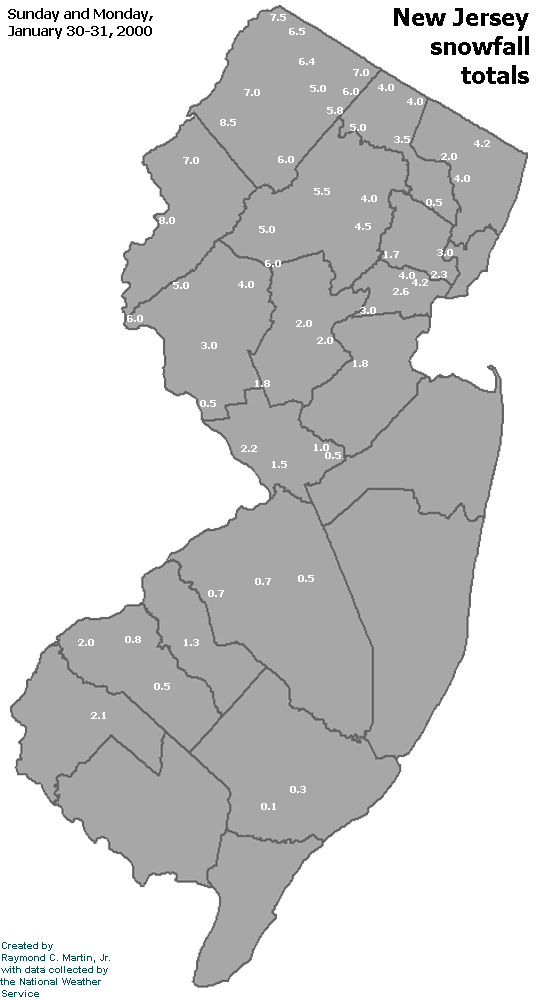
Individual Snowfall Totals from January 30-31, 2000
Regional Snowfall Totals
Snowfall totals from 0400Z 31 January 2000 (11PM EST 30 January 2000)
Table of Contents
Storm Summary
Regional Surface Observations
National Weather Service Forecasts
Surface Maps
Satellite Imagery
National Surface Weather Maps - Pressure and Fronts Only
Sea Level Pressure and 1000 to 500 Millibar Thickness Maps
850 Millibar Maps
700 Millibar Maps
500 Millibar Maps
300 Millibar Maps
200 Millibar Maps
National Radar Imagery
Local Radar Imagery
Fort Dix Doppler Radar Imagery
Snow storm, January 20, 2000
Snow and ice storm, January 25, 2000
Snow and ice storm, January 30-31, 2000
Snow storm, February 3, 2000
Snow and ice storm, February 18-19, 2000
Snow storm, April 9, 2000
Back to Ray's Winter Storm Archive
Copyright © 2012 by Raymond C Martin Jr. All rights reserved