

Storm description, surface observations, snowfall totals, and images courtesy of the National Climatic Data Center, the National Centers of Environmental Prediction, the Climate Prediction Center, the Hydrometeorological Prediction Center, the Mount Holly National Weather Service Office, the Upton National Weather Service Office, Rutgers University, Plymouth State University, the University of Illinois, the American Meteorological Society, Weather Graphics Technologies, AccuWeather, and the Weather Channel.
Table of Contents
Storm Summary
Regional Surface Observations
National Weather Service Forecasts
Surface Maps
Satellite Imagery
National Surface Weather Maps - Pressure and Fronts Only
Continental Surface Weather Maps - Pressure and Fronts Only
Sea Level Pressure and 1000 to 500 Millibar Thickness Maps
850 Millibar Maps
700 Millibar Maps
500 Millibar Maps
300 Millibar Maps
200 Millibar Maps
National Radar Imagery
Regional Radar Imagery
Fort Dix Doppler Radar Imagery
Contoured Snowfall Totals from December 14-15, 2003
STORM DESCRIPTION
Another storm system moving up the coast, combined with cold high pressure in place over New England, produced another round of snow across much of the state. Fortunately, this storm was much weaker than its predecessor.
Synoptic Discussion
A cold arctic high pressure system moved southeastward from Canada into northern New England, spreading cold air southward into the Mid-Atlantic states. Meanwhile, a low pressure sytem moved from near Mobile, Alabama on the evening of the 13th, northeastward to near Wilmington, North Carolina by the morning of the 14th. The low pressure then turned more to the north and was near Norfolk, Virginia at mid-day on the 14th, Delaware Bay by the evening of the 14th, and near New York City around midnight on the 15th. Because of the low pressure's track right along the coast, warm air was able to move inland over New Jersey, causing the snow to change to sleet, freezing rain and rain.
Local Discussion
Precipitation spread northeastward across the state during the morning hours of the 14th. It began as snow from Salem, Gloucester, Camden, Burlington, and Monmouth counties northward, but further south started as sleet, freezing rain or rain. Warm air began pushing quickly northwestward, causing the sleet and freezing rain to change to rain by late morning. The warm air continued northwestward across the state, causing the snow to change quickly to sleet, freezing rain and then rain across Salem, Gloucester, Camden, Burlington, and Monmouth counties by noon. The warm air continued northwestward, and the snow transitioned to rain across Mercer, Middlesex, Union, Essex, and Hudson counties by mid afternoon. The warm air then slowed and had more trouble scouring the cold air out of the hillier terrain of northwestern New Jersey. The snow changed to sleet, freezing rain and then rain much more slowly across Hunterdon, Somerset, Monmouth, Passaic and Bergen counties; the transition from snow to rain began in early afternoon but did not finish until early evening. This caused a more significant period of freezing rain and sleet to occur, allowing ice to accrue on most surfaces. However, the worst conditions were in the far northwestern counties of Warren and Sussex, where the warm air was never able to scour the cold air completely out and surface temperatures remained below freezing. These counties saw up to 0.5 inches of ice accrual, resulting in significant damage occured. Precipitation gradually tapered off during the night of the 14th from southwest to northeast. Snow fall accumulations were much lighter than in the previous storm, ranging from 5 to 7 inches in Passaic County, 3 to 7 inches in Morris County, 3 to 5 inches in Sussex, Warren, Bergen, Hudson, Essex, and Union counties, 2 to 4 inches in Middlesex, Somerset, and Hunterdon counties, 1 to 3 inches in Mercer County, and a coating to 2 inches in Monmouth, Burlington, Camden, Gloucester, and Salem counties. Less than 1 inch accumulated in Ocean, Atlantic, Cumberland and Cape May counties. This storm also featured strong gusty winds due to its rapid strengthening and the propagation of a gravity wave up the coast. Winds gusted to around 60 miles per hour along the Atlantic and Cape May county coasts, and up to 70 miles per hour along the Ocean and Monmouth county coasts.
New Jersey Snowfall Totals
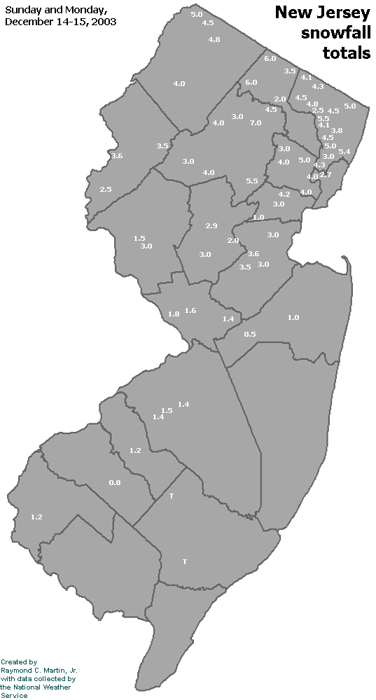
Individual Snowfall Totals from December 14-15, 2003
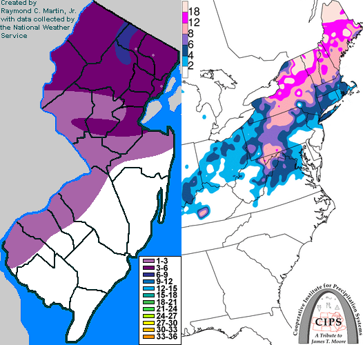
Regional Snowfall Totals
Snowfall Totals from 1700Z 15 December 2003 (12PM EST 15 December 2003)
Table of Contents
Storm Summary
Regional Surface Observations
National Weather Service Forecasts
Surface Maps
Satellite Imagery
National Surface Weather Maps - Pressure and Fronts Only
Continental Surface Weather Maps - Pressure and Fronts Only
Sea Level Pressure and 1000 to 500 Millibar Thickness Maps
850 Millibar Maps
700 Millibar Maps
500 Millibar Maps
300 Millibar Maps
200 Millibar Maps
National Radar Imagery
Regional Radar Imagery
Fort Dix Doppler Radar Imagery
Snow and ice storm, December 5-6, 2003
Snow storm, December 14-15, 2003
Snow storm, January 14-15, 2004
Snow and ice storm, January 17-18, 2004
Snow storm, January 26, 2004
Snow and ice storm, January 27-28, 2004
Snow and ice storm, March 16-17, 2004
Snow storm, March 18-19, 2004
Back to Ray's Winter Storm Archive
Copyright © 2012 by Raymond C Martin Jr. All rights reserved