

Storm description, surface observations, snowfall totals, and images courtesy of the National Climatic Data Center, the National Centers of Environmental Prediction, the Climate Prediction Center, the Hydrometeorological Prediction Center, the Mount Holly National Weather Service Office, the Upton National Weather Service Office, Rutgers University, Plymouth State University, the University of Illinois, the American Meteorological Society, Weather Graphics Technologies, AccuWeather, and the Weather Channel.
Table of Contents
Storm Summary
Regional Surface Observations
National Weather Service Forecasts
Surface Maps
Satellite Imagery
National Surface Weather Maps - Pressure and Fronts Only
Continental Surface Weather Maps - Pressure and Fronts Only
Sea Level Pressure and 1000 to 500 Millibar Thickness Maps
850 Millibar Maps
700 Millibar Maps
500 Millibar Maps
300 Millibar Maps
200 Millibar Maps
National Radar Imagery
Regional Radar Imagery
Fort Dix Doppler Radar Imagery
Storm Photos
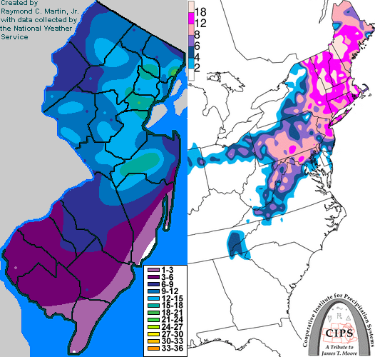
Contoured Snowfall Totals from December 5-6, 2003
STORM DESCRIPTION
The first winter storm of the 2003-2004 season was a strengthening nor'easter that dumped heavy snow across New Jersey on December 5th and 6th. In much of the state, this was also the heaviest snowstorm of the winter.
Synoptic Discussion
The primary surface low pressure was over the Gulf Coast on the morning of the 4th and moved northeast to Cape Hatteras by the morning of the 5th. It moved to just east of the Virginia Capes by the evening of the 5th, just east of Atlantic City on the morning of the 6th, and near Nantucket by the evening of the 6th. The heavy precipitation with the storm arrived in two parts. The first was with the primary surface low and occured during the day on the 5th. The second occured on the 6th as the upper-air component of the storm passed over the state.
Local Discussion
Snow spread from south to north across the state during the morning of the 5th, finally reaching Sussex County by early afternoon. The snow fell heavily at times, and was even accompanied by thunder and lightning in Trenton early in the afternoon. Warmer air moved northward early in the day, allowing the snow to change to rain across Gloucester, Salem, Atlantic, Cumberland, Ocean and Cape May counties. The snow also mixed with sleet further north in Camden, Burlington, and Monmouth counties, but warm air was unable to advance any further north. Precipitation tapered off during the late afternoon and evening hours as the primary low pressure began moving past the state. Two opposite occurances during the night of the 5th allowed light freezing precipitation to occur across southern parts of the state. First, warmer, drier air moved northward aloft, allowing what precipitation that did occur to melt before reaching the ground. Second, colder air moved southward at the surface as northerly winds developed behind the surface low pressure, allowing temperatures to fall below freezing across the entire state. The end result was widespread light freezing rain, freezing drizzle, sleet and snow during the night of the 5th from central New Jersey southward, while further north, precipitation remained in the form of snow. As the upper-level low pressure system approached the state on the morning of the 6th, temperatures aloft cooled back below freezing and widespread heavy snow developed. White-out conditions were widespread during the morning and afternoon of the 6th as heavy snow combined with strong and gusty northerly winds behind the strengthening surface low pressure. Snow finally began to taper off later in the afternoon on the 6th, and most areas of the state saw the snow end during the evening. Snow accumulations varried widely across the state due to the precipitation-type differences experienced over relatively short distances. Snow totals ranged from 8 to 22 inches in Bergen County, 10 to 15 inches in Passaic, Essex, Hudson, Union and Middlesex counties, 7 to 14 inches in Sussex, Morris, Warren, Hunterdon, Somerset and Mercer counties, 5 to 15 inches in Monmouth County, 2 to 13 inches in Ocean County, 3 to 10 inches in Burlington County, 4 to 7 inches in Camden and Gloucester counties, 1 to 7 inches in Atlantic County, 2 to 5 inches in Salem and Cumberland counties, and a trace to 2 inches in Cape May County. Ice accrual was light, with up to two-tenths of an inch reported in a few locations.
New Jersey Snowfall Totals
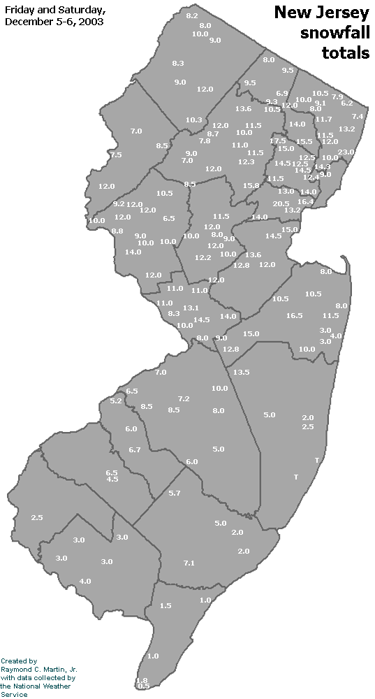
Individual Snowfall Totals from December 5-6, 2003
Regional Snowfall Totals
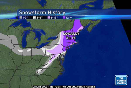
Snowfall Totals from 1200Z 08December 2003 (7AM EST 08 December 2003)
Table of Contents
Storm Summary
Regional Surface Observations
National Weather Service Forecasts
Surface Maps
Satellite Imagery
National Surface Weather Maps - Pressure and Fronts Only
Continental Surface Weather Maps - Pressure and Fronts Only
Sea Level Pressure and 1000 to 500 Millibar Thickness Maps
850 Millibar Maps
700 Millibar Maps
500 Millibar Maps
300 Millibar Maps
200 Millibar Maps
National Radar Imagery
Regional Radar Imagery
Fort Dix Doppler Radar Imagery
Storm Photos
Snow and ice storm, December 5-6, 2003
Snow storm, December 14-15, 2003
Snow storm, January 14-15, 2004
Snow and ice storm, January 17-18, 2004
Snow storm, January 26, 2004
Snow and ice storm, January 27-28, 2004
Snow and ice storm, March 16-17, 2004
Snow storm, March 18-19, 2004
Back to Ray's Winter Storm Archive
Copyright © 2012 by Raymond C Martin Jr. All rights reserved