

Storm description, surface observations, snowfall totals, and images courtesy of the National Climatic Data Center, the National Centers of Environmental Prediction, the Climate Prediction Center, the Hydrometeorological Prediction Center, the Mount Holly National Weather Service Office, the Upton National Weather Service Office, Rutgers University, Plymouth State University, the University of Illinois, the American Meteorological Society, Weather Graphics Technologies, AccuWeather, and the Weather Channel.
Table of Contents
Storm Summary
Regional Surface Observations
National Weather Service Forecasts
Surface Maps
Satellite Imagery
National Surface Weather Maps - Pressure and Fronts Only
Continental Surface Weather Maps - Pressure and Fronts Only
Sea Level Pressure and 1000 to 500 Millibar Thickness Maps
850 Millibar Maps
700 Millibar Maps
500 Millibar Maps
300 Millibar Maps
200 Millibar Maps
National Radar Imagery
Regional Radar Imagery
Fort Dix Doppler Radar Imagery
Contoured Snowfall Totals from January 17-18, 2004
STORM DESCRIPTION
A low pressure system from the southern Plains combined with a cold front from the upper Mississippi Valley to bring a wintry mix of precipitation across much of New Jersey, with accumulating snow in the north.
Synoptic Discussion
The low pressure system responsible for the wintry mix moved from the Oklahoma-Texas border on the morning of the 17th to the Tennessee Valley on the morning of the 18th and then east of Long Island by the evening of the 18th. At the same time, a cold front moved east-southeast from the upper Mississippi Valley on the morning of the 17th to New Jersey by the afternoon of the 18th. The moisture from the low pressure system combined with the lifting provided by the cold front to produce wintry precipitation over New Jersey.
Local Discussion
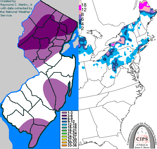
Light snow and flurries spread east-southeast across most of the state during the evening of the 17th. During the morning of the 18th, warmer air both aloft and at the surface began spreading northward, causing the snow to change to sleet, freezing rain and finally rain across much of the state. Cold air lingered from Hunterdon, Morris and Essex counties northward, where precipitation only briefly changed to freezing rain before changing back to snow as the cold front pushed southeastward around midday. The rain/snow line continued progressing back to the south during the afternoon, but moisture was also rapidly vacating the state as the low pressure system moved eastward away from New Jersey. The rain briefly changed back to snow as far south as Salem, Gloucester, Camden, Burlington and Ocean counties before precipitation ended state-wide. Accumulating snow was limited to northern parts of the state, including 3 to 5 inches in Morris County, 2 to 5 inches in Bergen County, 2 to 4 inches in Warren, Hunterdon, Essex, and Passaic counties, 1 to 3 inches in Sussex, Hudson, and Somerset counties, 1 to 2 inches in Middlesex and Mercer counties, and generally less than 1 inch from Monmouth and Burlington counties southward. Ice accretion was generally less than one tenth of an inch state-wide.
New Jersey Snowfall Totals
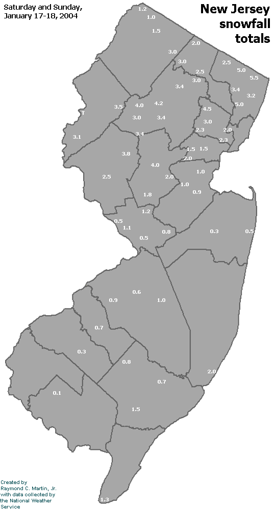
Individual Snowfall Totals from January 17-18, 2004
Table of Contents
Storm Summary
Regional Surface Observations
National Weather Service Forecasts
Surface Maps
Satellite Imagery
National Surface Weather Maps - Pressure and Fronts Only
Continental Surface Weather Maps - Pressure and Fronts Only
Sea Level Pressure and 1000 to 500 Millibar Thickness Maps
850 Millibar Maps
700 Millibar Maps
500 Millibar Maps
300 Millibar Maps
200 Millibar Maps
National Radar Imagery
Regional Radar Imagery
Fort Dix Doppler Radar Imagery
Snow and ice storm, December 5-6, 2003
Snow storm, December 14-15, 2003
Snow storm, January 14-15, 2004
Snow and ice storm, January 17-18, 2004
Snow storm, January 26, 2004
Snow and ice storm, January 27-28, 2004
Snow and ice storm, March 16-17, 2004
Snow storm, March 18-19, 2004
Back to Ray's Winter Storm Archive
Copyright © 2012 by Raymond C Martin Jr. All rights reserved