

Storm description, surface observations, snowfall totals, and images courtesy of the National Climatic Data Center, the National Centers of Environmental Prediction, the Climate Prediction Center, the Hydrometeorological Prediction Center, the Mount Holly National Weather Service Office, the Upton National Weather Service Office, Rutgers University, Plymouth State University, the University of Illinois, the American Meteorological Society, Weather Graphics Technologies, AccuWeather, and the Weather Channel.
Table of Contents
Storm Summary
Regional Surface Observations
National Weather Service Forecasts
Surface Maps
Satellite Imagery
National Surface Weather Maps - Pressure and Fronts Only
Continental Surface Weather Maps - Pressure and Fronts Only
Sea Level Pressure and 1000 to 500 Millibar Thickness Maps
850 Millibar Maps
700 Millibar Maps
500 Millibar Maps
300 Millibar Maps
200 Millibar Maps
National Radar Imagery
Regional Radar Imagery
Fort Dix Doppler Radar Imagery
Contoured Snowfall Totals from December 16-17, 2008
STORM DESCRIPTION
A wave of low pressure riding northeastward along a stalled frontal boundary brought the first widespread snowfall to much of northern and central New Jersey.
Synoptic Discussion
A cold front moved across the Mid-Atlantic states during the afternoon of the 15th. Arctic high pressure building in behind the front caused cold air to seep southward into New Jersey on the night of the 15th and during the day on the 16th. At the same time, the cold front stalled over the Carolinas as a low pressure developed near the Gulf Coast and moved northeastward along the stalled front. On the night of the 16th, the primary low pressure moved northeastward west of the Appalachians while a secondary low developed off the Mid-Atlantic coast. By the afternoon of the 17th, this second low was moving out to sea east of Cape Cod while the primary low weakened over the eastern Great Lakes.
Local Discussion
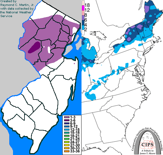
Precipitation moved into New Jersey during the mid-day hours on the 16th. Across southern New Jersey, a mixture of rain and sleet fell, while a mixture of sleet and snow fell across central New Jersey, and precipitation was mainly in the form of snow at the start across the north. During the evening hours of the 16th, precipitation gradually transitioned toward warmer phases, with mainly rain in the south, sleet and freezing rain across central New Jersey, and sleet and snow across the north. By the early morning hours of the 17th, precipitation was mainly rain with a few pockets of freezing rain across southern and central New Jersey, while sleet and freezing rain fell across the north. Precipitation tapered off to drizzle and isolated showers before dawn on the 17th state-wide. Snowfall accumulations were highest across west-central New Jersey, with lesser amounts elsewhere. 1 to 4 inches fell across Hunterdon County, 1 to 3 inches fell across Morris, Warren, Essex, Union, and Somerset counties, a coating to 2 inches fell across Sussex, Passaic, Bergen, Hudson, Middlesex, and Mercer counties, and up to a coating fell across Burlington and Monmouth counties. Little or no snow and sleet accumulated further south.
New Jersey Snowfall Totals
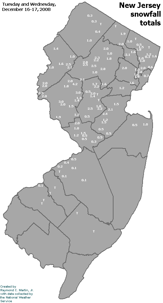
Individual Snowfall Totals from December 16-17, 2008
Table of Contents
Storm Summary
Regional Surface Observations
National Weather Service Forecasts
Surface Maps
Satellite Imagery
National Surface Weather Maps - Pressure and Fronts Only
Continental Surface Weather Maps - Pressure and Fronts Only
Sea Level Pressure and 1000 to 500 Millibar Thickness Maps
850 Millibar Maps
700 Millibar Maps
500 Millibar Maps
300 Millibar Maps
200 Millibar Maps
National Radar Imagery
Regional Radar Imagery
Fort Dix Doppler Radar Imagery
Snow and ice storm, December 16-17, 2008
Snow storm, January 19, 2009
Snow and ice storm, January 27-28, 2009
Snow storm, February 2-4, 2009
Snow storm, March 1-2, 2009
Back to Ray's Winter Storm Archive
Copyright © 2012 by Raymond C Martin Jr. All rights reserved