

Storm description, surface observations, snowfall totals, and images courtesy of the National Climatic Data Center, the National Centers of Environmental Prediction, the Climate Prediction Center, the Hydrometeorological Prediction Center, the Mount Holly National Weather Service Office, the Upton National Weather Service Office, Rutgers University, Plymouth State University, the University of Illinois, the American Meteorological Society, Weather Graphics Technologies, AccuWeather, and the Weather Channel.
Table of Contents
Storm Summary
Regional Surface Observations
National Weather Service Forecasts
Surface Maps
Satellite Imagery
National Surface Weather Maps - Pressure and Fronts Only
Continental Surface Weather Maps - Pressure and Fronts Only
Sea Level Pressure and 1000 to 500 Millibar Thickness Maps
850 Millibar Maps
700 Millibar Maps
500 Millibar Maps
300 Millibar Maps
200 Millibar Maps
National Radar Imagery
Regional Radar Imagery
Fort Dix Doppler Radar Imagery
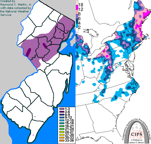
Contoured Snowfall Totals from January 19, 2009
STORM DESCRIPTION
A weak clipper-like storm system brought a swath of snow to parts of central and northern New Jersey.
Synoptic Discussion
On the 18th and 19th, a series of weak storm systems moved east-northeastward along the Mid-Atlantic coast. Each one produced a slightly different swath of snowfall, with one on the early morning of the 18th being across northern New Jersey and another on the evening of the 18th being across southeastern New Jersey. The third system during the afternoon of the 19th brought a swath of snow across central and northeastern New Jersey. These systems all originated from the central United States and departed northeastward toward the Canadian Maritimes.
Local Discussion
Precipitation from the third system overspread New Jersey from southwest to northeast during the late morning and early afternoon of the 19th. One band of snow moved across southeastern New Jersey, while a second, heavier band moved across central and northeastern New Jersey. This second band, where the snow was heavy at times, produced the most accumulation before precipitation tapered off from southwest to northeast during the early evening hours. Snowfall accumulations reached 1 to 3 inches across Hunterdon, Somerset, Union, Essex and Passaic counties, a coating to 2 inches across Morris, Passaic, Hudson, Middlesex, and Mercer counties, and a coating to 1 inch across Warren, Atlantic and Cape May counties. Less snow fell elsewhere.
New Jersey Snowfall Totals
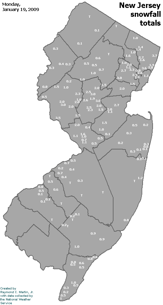
Individual Snowfall Totals from January 19, 2009
Table of Contents
Storm Summary
Regional Surface Observations
National Weather Service Forecasts
Surface Maps
Satellite Imagery
National Surface Weather Maps - Pressure and Fronts Only
Continental Surface Weather Maps - Pressure and Fronts Only
Sea Level Pressure and 1000 to 500 Millibar Thickness Maps
850 Millibar Maps
700 Millibar Maps
500 Millibar Maps
300 Millibar Maps
200 Millibar Maps
National Radar Imagery
Regional Radar Imagery
Fort Dix Doppler Radar Imagery
Snow and ice storm, December 16-17, 2008
Snow storm, January 19, 2009
Snow and ice storm, January 27-28, 2009
Snow storm, February 2-4, 2009
Snow storm, March 1-2, 2009
Back to Ray's Winter Storm Archive
Copyright © 2012 by Raymond C Martin Jr. All rights reserved