

Storm description, surface observations, snowfall totals, and images courtesy of the National Climatic Data Center, the National Centers of Environmental Prediction, the Climate Prediction Center, the Hydrometeorological Prediction Center, the Mount Holly National Weather Service Office, the Upton National Weather Service Office, Rutgers University, Plymouth State University, the University of Illinois, the American Meteorological Society, Weather Graphics Technologies, AccuWeather, and the Weather Channel.
Table of Contents
Storm Summary
Regional Surface Observations
National Weather Service Forecasts
Surface Maps
Satellite Imagery
National Surface Weather Maps - Pressure and Fronts Only
Continental Surface Weather Maps - Pressure and Fronts Only
Sea Level Pressure and 1000 to 500 Millibar Thickness Maps
850 Millibar Maps
700 Millibar Maps
500 Millibar Maps
300 Millibar Maps
200 Millibar Maps
National Radar Imagery
Regional Radar Imagery
Fort Dix Doppler Radar Imagery
Contoured Snowfall Totals from February 2-4, 2009
STORM DESCRIPTION
The combination of a passing cold front and a developing coastal storm brought a moderate snowfall to much of New Jersey.
Synoptic Discussion
A cold front moved across New Jersey during the day on the 2nd. Cold air associated with high pressure behind the front moved into the state during the evening of the 2nd. Meanwhile, a low pressure also developed along the cold front in the southeastern states on the 2nd, causing the front to stall. The low pressure moved northeastward along the stalled front during the day on the 3rd, passing a few hundred miles east of Atlantic City during the morning and approaching the Canadian Maritimes during the evening. At the same time, an upper-level disturbance moved eastward from the Great Lakes, passing over New Jersey during the overnight hours of the 3rd. By the morning of the 4th, the upper-level disturbance had passed well off the East Coast.
Local Discussion
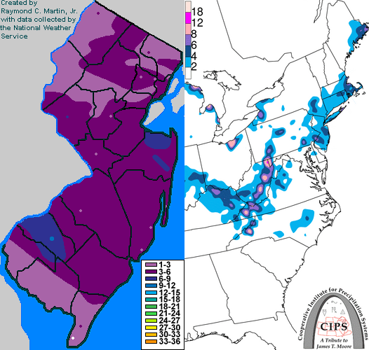
A mixture of rain and snow gradually overspread New Jersey from west to east during the late evening and overnight hours on the 2nd. Although precipitation gradually transitioned to all snow by the morning of the 3rd, surface temperatures remained near or slightly above freezing and the snow remained fairly light in intensity, reducing snowfall accumulations. Precipitation started moving northeastward out of the state during the late morning hours on the 3rd, but then began redeveloping back toward the southwest as the upper-level disturbance approached during the afternoon. Two distinct bands of heavier snow developed during the late afternoon and evening. The first, which occurred mainly during the late afternoon and early evening, was focused on Monmuth County in east-central New Jersey. The second, which developed during the mid to late evening, was focused on Gloucester County in southwestern New Jersey. Temperatures across the state fell into the upper 20s during the heavier snow, which also allowed the snow to accumulate more efficiently. The snow tapered off from north to south during the late evening and early overnight hours of the 3rd. Total accumulations ranged from 6 to 10 inches in Gloucester County, 3 to 7 inches in Monmouth and Salem counties, 2 to 6 inches in Hunterdon County, 3 to 5 inches in Atlantic, Camden, Burlington, Ocean, Mercer, Somerset, and Middlesex counties, 2 to 4 inches in Cumberland, Union, Essex, Hudson, Bergen, Morris, Passaic, Sussex and Warren counties, and 1 to 3 inches in Cape May County.
New Jersey Snowfall Totals
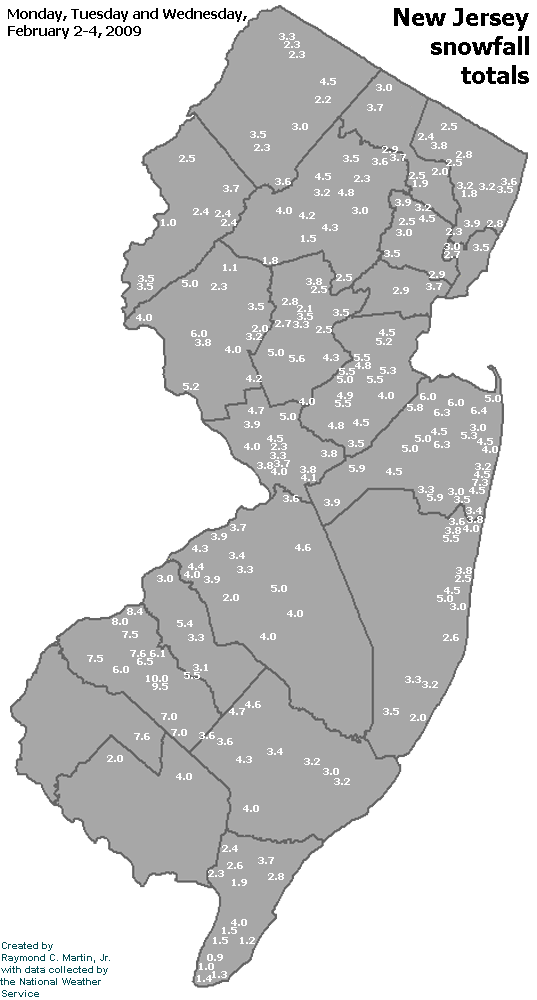
Individual Snowfall Totals from February 2-4, 2009
Table of Contents
Storm Summary
Regional Surface Observations
National Weather Service Forecasts
Surface Maps
Satellite Imagery
National Surface Weather Maps - Pressure and Fronts Only
Continental Surface Weather Maps - Pressure and Fronts Only
Sea Level Pressure and 1000 to 500 Millibar Thickness Maps
850 Millibar Maps
700 Millibar Maps
500 Millibar Maps
300 Millibar Maps
200 Millibar Maps
National Radar Imagery
Regional Radar Imagery
Fort Dix Doppler Radar Imagery
Snow and ice storm, December 16-17, 2008
Snow storm, January 19, 2009
Snow and ice storm, January 27-28, 2009
Snow storm, February 2-4, 2009
Snow storm, March 1-2, 2009
Back to Ray's Winter Storm Archive
Copyright © 2012 by Raymond C Martin Jr. All rights reserved