

Storm description, surface observations, snowfall totals, and images courtesy of the National Climatic Data Center, the National Centers of Environmental Prediction, the Climate Prediction Center, the Hydrometeorological Prediction Center, the Mount Holly National Weather Service Office, the Upton National Weather Service Office, Rutgers University, Plymouth State University, the University of Illinois, the American Meteorological Society, Weather Graphics Technologies, AccuWeather, and the Weather Channel.
Table of Contents
Storm Summary
Regional Surface Observations
Satellite Imagery
Sea Level Pressure and 1000 to 500 Millibar Thickness Maps
850 Millibar Maps
700 Millibar Maps
500 Millibar Maps
300 Millibar Maps
200 Millibar Maps
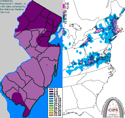
Contoured Snowfall Totals from December 29-30, 1993
STORM DESCRIPTION
The first snow of the 1993-1994 season in New Jersey arrived with a complex low pressure system in late December.
Synoptic Discussion
A weak storm system moved southeastward across central Canada and then eastward across the Great Lakes during the 28th and 29th. As the storm reached the St. Lawrence Valley, energy began to transfer to a new low pressure that developed along a stalled frontal boundary southeast of the Mid-Atlantic coast. This new low pressure became the primary storm system as it moved northeastward toward Nova Scotia by the 30th.
Local Discussion
Snow developed across the state during the midday hours of the 29th as the primary low pressure system's cold front approached from the west while the secondary low pressure began developiing to the southeast. Snow continued through the afternoon and evening of the 29th, remaining light but steady, until finally departing northeastward around midnight on the 30th. Accumulations averaged 1 to 4 inches state-wide, with the highest amounts in the north and extreme south.
New Jersey Snowfall Totals
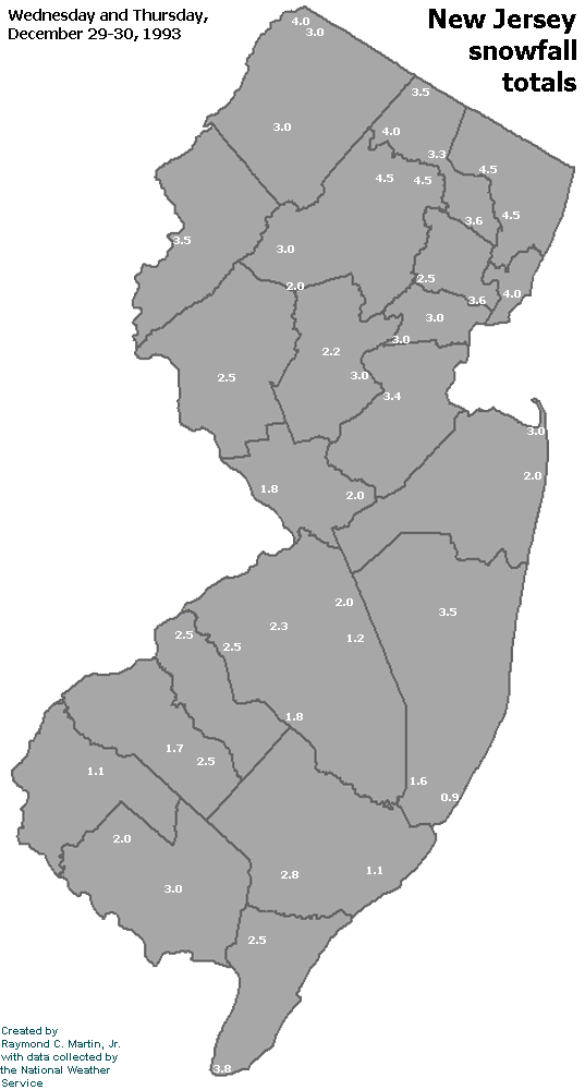
Individual Snowfall Totals from December 29-30, 1993
Table of Contents
Storm Summary
Regional Surface Observations
Satellite Imagery
Sea Level Pressure and 1000 to 500 Millibar Thickness Maps
850 Millibar Maps
700 Millibar Maps
500 Millibar Maps
300 Millibar Maps
200 Millibar Maps
Snow storm, December 29-30, 1993
Ice storm, January 3-4, 1994
Ice storm, January 7-8, 1994
Snow and ice storm, January 17-18, 1994
Snow storm, January 25-26, 1994
Snow and ice storm, February 8-9, 1994
Snow and ice storm, February 11, 1994
Snow and ice storm, February 23-24, 1994
Snow and ice storm, March 2-3, 1994
Snow storm, March 18, 1994
Back to Ray's Winter Storm Archive
Copyright © 2012 by Raymond C Martin Jr. All rights reserved