

Storm description, surface observations, snowfall totals, and images courtesy of the National Climatic Data Center, the National Centers of Environmental Prediction, the Climate Prediction Center, the Hydrometeorological Prediction Center, the Mount Holly National Weather Service Office, the Upton National Weather Service Office, Rutgers University, Plymouth State University, the University of Illinois, the American Meteorological Society, Weather Graphics Technologies, AccuWeather, and the Weather Channel.
Table of Contents
Storm Summary
Regional Surface Observations
Satellite Imagery
National Surface Weather Maps - Pressure and Fronts Only
Sea Level Pressure and 1000 to 500 Millibar Thickness Maps
850 Millibar Maps
700 Millibar Maps
500 Millibar Maps
300 Millibar Maps
200 Millibar Maps
National Radar Imagery
Fort Dix Doppler Radar Imagery
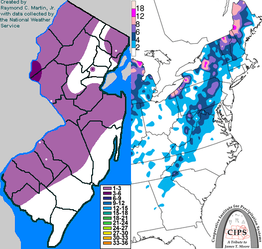
Contoured Snowfall Totals from December 19-20, 2000
STORM DESCRIPTION
An Alberta Clipper redeveloped off the coast of New Jersey, bringing the first snowfall of the 2000-2001 winter season to the state.
Synoptic Discussion
A primary low pressure system moved southeastward into the eastern Great Lakes on the afternoon of the 19th. Meanwhile, a secondary low pressure developed just east of the New Jersey coast during the evening hours of the 19th and early morning of the 20th. The primary low pressure weakened as it approaches upstate New York, and the rapidly strengthening secondary low became the primary low. The new primary low moved northeastward toward Atlantic Canada on the morning of the 20th.
Local Discussion
Precipitation associated with the developing coastal low pressure system remained east of New Jersey during the evening of the 19th, and was mainly in the form of rain. The upper-level energy associated with the original low back over the Great Lakes moved across the state during the night of the 19th. This caused snow to overspread the state between 9PM EST on the 19th and midnight EST on the 20th. The snow continued for much of the night, finally moving eastward out to sea during the predawn hours of the 20th. Accumulations ranged from a coating to 2 inches across most of the state, with a maximum of 3 inches in southwestern Warren County and northwestern Hunterdon County.
New Jersey Snowfall Totals
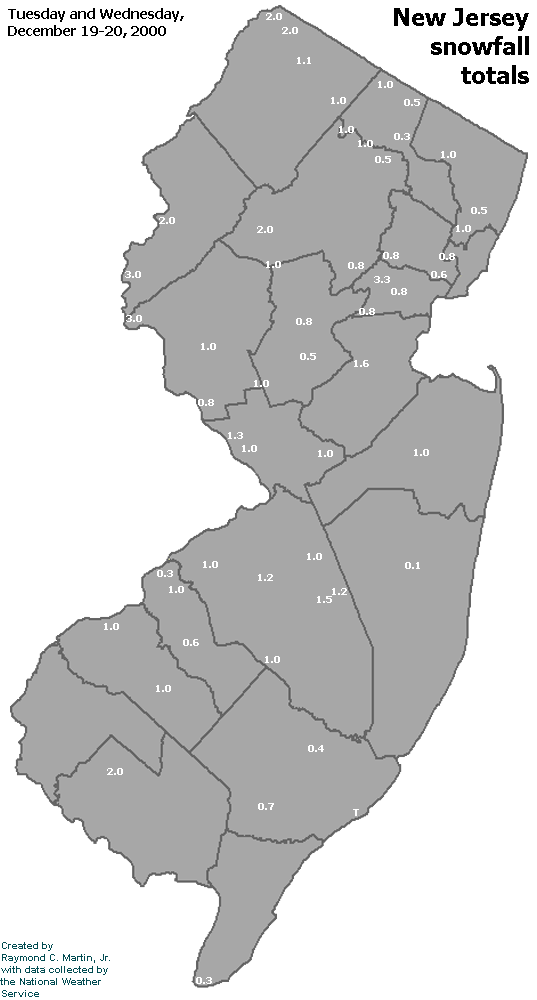
Individual Snowfall Totals from December 19-20, 2000
Table of Contents
Storm Summary
Regional Surface Observations
Satellite Imagery
National Surface Weather Maps - Pressure and Fronts Only
Sea Level Pressure and 1000 to 500 Millibar Thickness Maps
850 Millibar Maps
700 Millibar Maps
500 Millibar Maps
300 Millibar Maps
200 Millibar Maps
National Radar Imagery
Fort Dix Doppler Radar Imagery
Snow storm, December 19-20, 2000
Snow storm, December 22, 2000
Snow storm, December 30, 2000
Snow storm, January 5, 2001
Snow and ice storm, January 20-21, 2001
Snow storm, February 5, 2001
Snow storm, February 22, 2001
Snow and ice storm, March 4-6, 2001
Back to Ray's Winter Storm Archive
Copyright © 2012 by Raymond C Martin Jr. All rights reserved