

Storm description, surface observations, snowfall totals, and images courtesy of the National Climatic Data Center, the National Centers of Environmental Prediction, the Climate Prediction Center, the Hydrometeorological Prediction Center, the Mount Holly National Weather Service Office, the Upton National Weather Service Office, Rutgers University, Plymouth State University, the University of Illinois, the American Meteorological Society, Weather Graphics Technologies, AccuWeather, and the Weather Channel.
Table of Contents
Storm Summary
Regional Surface Observations
National Weather Service Forecasts
Surface Maps
Satellite Imagery
National Surface Weather Maps - Pressure and Fronts Only
Continental Surface Weather Maps - Pressure and Fronts Only
Sea Level Pressure and 1000 to 500 Millibar Thickness Maps
850 Millibar Maps
700 Millibar Maps
500 Millibar Maps
300 Millibar Maps
200 Millibar Maps
National Radar Imagery
Regional Radar Imagery
Fort Dix Doppler Radar Imagery
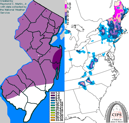
Contoured Snowfall Totals from March 8, 2005
STORM DESCRIPTION
A rapidly strengthening storm system brought a quick burst of snow across most of the state, accompanied by very strong and gusty winds. For southern and central New Jersey, this was the final snowstorm of the season.
Synoptic Discussion
A strong low pressure system, accompanied by a powerful cold front, moved southeastward into the northern Plains from Canada during the day on the 6th. By the morning of the 7th, the low pressure was moving across Lake Michigan, and by that evening it was passing north of Lake Ontario. As the storm system and the powerful cold front accompanying it reached the coast on the morning of the 8th, the center redeveloped further south along the cold front as it crossed the Delmarva peninsula. It moved northeastward off the coast of New Jersey and rapidly strengthened as the upper-level trough associated with the surface low pressure switched from a positive tilt (aligned northeast to southwest) to a negative tilt (aligned northwest to southeast). The surface low continued strengthening as it moved northeastward to near Cape Cod by the evening of the 8th. By the morning of the 9th, the storm was over the Canadian maritimes.
Local Discussion
Rain broke out across the state during the early morning hours of the 8th and became heavy at times by sunrise. As the powerful cold front crossed the state during the morning, temperatures fell rapidly from the 40s into the 20s, causing the rain to change to snow. Rain changed to snow by 9 AM EST across Sussex and Warren counties, by 10 AM EST in Passaic, Morris and Hunterdon counties, by 11 AM EST in Bergen, Hudson, Essex, Union, Somerset, Middlesex, Mercer, northwestern Burlington, Camden and Gloucester counties, and by 12 PM EST across Monmouth, Ocean, southeastern Burlington, Atlantic, Salem, Cumberland and Cape May counties. The snow continued into the early afternoon, accompanied by very strong wind gusts which exceeded 50 miles per hour and created near-blizzard conditions. The snow gradually tapered off from southwest to northeast during the late afternoon and early evening of the 8th. Snow accumulations ranged from 1 to 4 inches across most of the state, with less than 1 inch in Cape May and Atlantic counties along with parts of Gloucester, Salem and Cumberland counties.
New Jersey Snowfall Totals
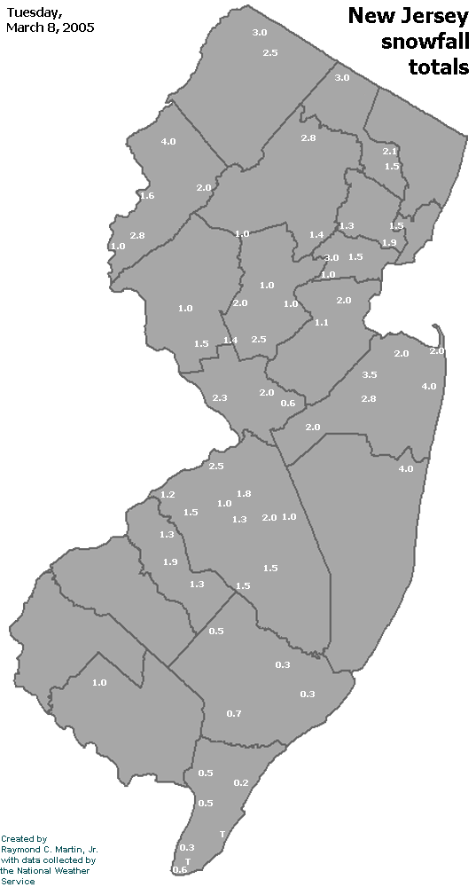
Individual Snowfall Totals from March 8, 2005
Table of Contents
Storm Summary
Regional Surface Observations
National Weather Service Forecasts
Surface Maps
Satellite Imagery
National Surface Weather Maps - Pressure and Fronts Only
Continental Surface Weather Maps - Pressure and Fronts Only
Sea Level Pressure and 1000 to 500 Millibar Thickness Maps
850 Millibar Maps
700 Millibar Maps
500 Millibar Maps
300 Millibar Maps
200 Millibar Maps
National Radar Imagery
Regional Radar Imagery
Fort Dix Doppler Radar Imagery
Snow storm, December 26-27, 2004
Snow storm, January 19, 2005
Snow storm, January 22-23, 2005
Snow storm, February 20-21, 2005
Snow storm, February 24-25, 2005
Snow storm, February 28-March 1, 2005
Snow storm, March 8, 2005
Back to Ray's Winter Storm Archive
Copyright © 2012 by Raymond C Martin Jr. All rights reserved