

Storm description, surface observations, snowfall totals, and images courtesy of the National Climatic Data Center, the National Centers of Environmental Prediction, the Climate Prediction Center, the Hydrometeorological Prediction Center, the Mount Holly National Weather Service Office, the Upton National Weather Service Office, Rutgers University, Plymouth State University, the University of Illinois, the American Meteorological Society, Weather Graphics Technologies, AccuWeather, and the Weather Channel.
Table of Contents
Storm Summary
Regional Surface Observations
National Weather Service Forecasts
Surface Maps
Satellite Imagery
National Surface Weather Maps - Pressure and Fronts Only
Continental Surface Weather Maps - Pressure and Fronts Only
Sea Level Pressure and 1000 to 500 Millibar Thickness Maps
850 Millibar Maps
700 Millibar Maps
500 Millibar Maps
300 Millibar Maps
200 Millibar Maps
National Radar Imagery
Regional Radar Imagery
Fort Dix Doppler Radar Imagery
Storm Photos
Contoured Snowfall Totals from December 26-27, 2004
STORM DESCRIPTION
The combination of a coastal storm and an upper-level disturbance resulted in the first widespread snowfall of the Winter of 2004-2005 across most of New Jersey.
Synoptic Discussion
The surface low pressure developed along an old cold front in the western Gulf of Mexico on December 24th. It moved eastward to Florida on the 25th and turned northeastward up the East Coast on the morning of the 26th.. Meanwhile, an upper-level disturbance moved southeastward across the Great Lakes during the day on the 26th. By the evening of the 26th, the surface low pressure was off the coast of Cape Hatteras, North Carolina, and began to rapidly strengthen as it started to interact with the upper-level disturbance from Canada. The upper-level disturbance moved across New Jersey on the morning of the 27th, while the surface low pressure, having explosively deepened overnight, was already approaching Nova Scotia. Both systems had cleared the state by noon.
Local Discussion
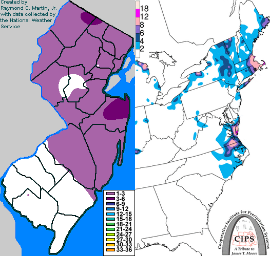
Heavy snow associated with the surface low pressure spread northeastward during the day on the 26th, but dry air and westerly winds at upper-levels of the atmosphere kept this precipitation just off the coast of New Jersey, with only some light snow reaching coastal Cape May County. In the afternoon, a band of light ocean-effect snow showers also moved inland on strong northeasterly winds in northern New Jersey, but produced little more than a dusting. During the evening, the main snow band backed further west and enveloped parts of the northern New Jersey coast as the storm began to rapidly intensify, but accumulations were less than an inch. Later in the evening, the upper-level disturbance approached from the northwest, causing light snow to break out across northwestern New Jersey and eastern Pennsylvania. As the disturbance moved southeastward, this snow spread across the rest of New Jersey ahead of it. The snow gradually ended from northwest to southeast around dawn on the 27th as the upper-level disturbance crossed the state. Snowfall accumulations generally ranged from 1 to 3 inches across northern and central New Jersey, with up to 1 inch in southern New Jersey.
New Jersey Snowfall Totals
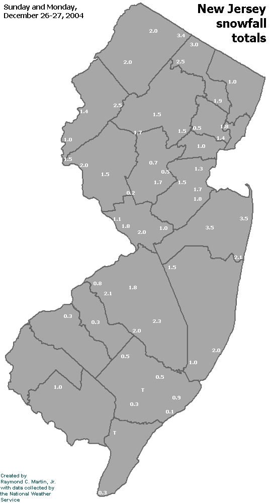
Individual Snowfall Totals from December 26-27, 2004
Regional Snowfall Totals
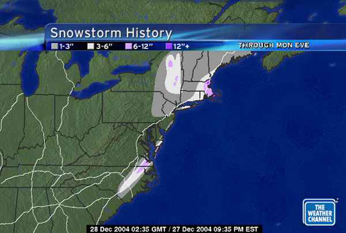
Snowfall Totals from 0300Z 28 December 2004 (10PM EST 27 December 2004)
Table of Contents
Storm Summary
Regional Surface Observations
National Weather Service Forecasts
Surface Maps
Satellite Imagery
National Surface Weather Maps - Pressure and Fronts Only
Continental Surface Weather Maps - Pressure and Fronts Only
Sea Level Pressure and 1000 to 500 Millibar Thickness Maps
850 Millibar Maps
700 Millibar Maps
500 Millibar Maps
300 Millibar Maps
200 Millibar Maps
National Radar Imagery
Regional Radar Imagery
Fort Dix Doppler Radar Imagery
Storm Photos
Snow storm, December 26-27, 2004
Snow storm, January 19, 2005
Snow storm, January 22-23, 2005
Snow storm, February 20-21, 2005
Snow storm, February 24-25, 2005
Snow storm, February 28-March 1, 2005
Snow storm, March 8, 2005
Back to Ray's Winter Storm Archive
Copyright © 2012 by Raymond C Martin Jr. All rights reserved