

Storm description, surface observations, snowfall totals, and images courtesy of the National Climatic Data Center, the National Centers of Environmental Prediction, the Climate Prediction Center, the Hydrometeorological Prediction Center, the Mount Holly National Weather Service Office, the Upton National Weather Service Office, Rutgers University, Plymouth State University, the University of Illinois, the American Meteorological Society, Weather Graphics Technologies, AccuWeather, and the Weather Channel.
Table of Contents
Storm Summary
Regional Surface Observations
National Weather Service Forecasts
Surface Maps
Satellite Imagery
National Surface Weather Maps - Pressure and Fronts Only
Continental Surface Weather Maps - Pressure and Fronts Only
Sea Level Pressure and 1000 to 500 Millibar Thickness Maps
850 Millibar Maps
700 Millibar Maps
500 Millibar Maps
300 Millibar Maps
200 Millibar Maps
National Radar Imagery
Regional Radar Imagery
Fort Dix Doppler Radar Imagery
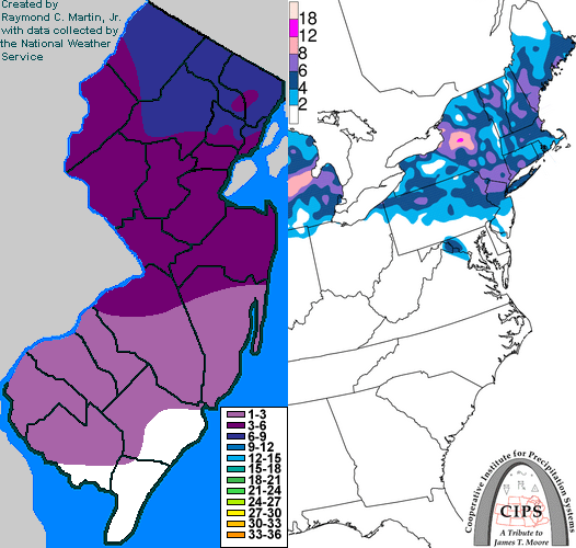
Contoured Snowfall Totals from February 20-21, 2005
STORM DESCRIPTION
A storm system moving northeastward from the southern Rockies to the Great Lakes and southern Ontario caused a light to moderate snowstorm across most of the state.
Synoptic Discussion
The low pressure system emerged from the southern Rockies into the western High Plains of Colorado on the morning of the 19th. It moved east-northeastward, reaching Iowa on the morning of the 20th. Meanwhile, a cold front pushed southward across the Northeast late on the 19th and early on the 20th, providing a reinforcing shot of cold, dry air. The low pressure system reached northern Illinois on the evening of the 20th. By the morning of the 21st, it was in southern Ontario, Canada, with a warm front extending southeastward to New Jersey and out over the open Atlantic. The primary low then weakened and a secondary low developed on the warm front off the coast of New Jersey. By the evening of the 21st, the primary low was dissipating. The secondary low pressure was south of Cape Cod and continued moving east-northeast away from New Jersey.
Local Discussion
Snow spread from west to east across northern and central New Jersey during the early evening of the 20th. The recent cold front passage had left a very dry airmass over the state and the nearby Atlantic Ocean, and this caused a delay in the beginning of the snowfall as well as a significant temperature drop due to evaporational cooling as the snow finally began. This was significant because most areas had been near 40 degrees just a few hours before the snow began. Meanwhile, an unusual southeasterly wind was blowing across most of the state. Under normal circumstances, especially earlier in the winter season, a southeasterly wind would quickly bring warmer air in from the Atlantic, but because the airmass over the adjacent coastal waters was fresh and had not yet taken on the characteristics of the ocean water beneath it, and because the ocean is typically coldest in February, the usual warming effect of a southeasterly wind did not occur. The snow moved into southern New Jersey later in the evening and became occasionally heavy state-wide from near midnight until the predawn hours of the 21st as the strongest warm advection moved across the state. Some lightning and thunder was even reported in parts of southern New Jersey as the heaviest bands of snow moved through. Warm advection decreased late at night as the air aloft finally warmed above freezing, and the snow changed to sleet, freezing rain and briefly rain as it ended from southwest to northeast between 3AM EST and 8AM EST on the 21st. Accumulations were heaviest across northern New Jersey where the snow started first and ended last, ranging from 6 to 8 inches in Sussex and Morris counties, 5 to 8 inches in Passaic and Essex counties, 5 to 7 inches in Bergen County, 5 to 6 inches in Hudson County, 4 to 6 inches in Union, Hunterdon and Warren counties, 4 to 5 inches in Somerset County, 3 to 5 inches in Mercer and Middlesex counties, 3 to 4 inches in Monmouth County, 1 to 4 inches in Burlington and Ocean counties, 2 to 3 inches in Camden County, 1 to 2 inches in Gloucester County, and up to 2 inches in Salem, Cumberland, Atlantic and Cape May counties. Little or no freezing rain or sleet accumulated.
New Jersey Snowfall Totals
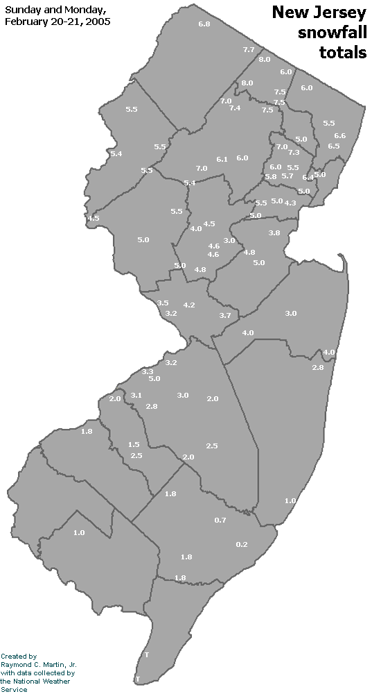
Individual Snowfall Totals from February 20-21, 2005
Table of Contents
Storm Summary
Regional Surface Observations
National Weather Service Forecasts
Surface Maps
Satellite Imagery
National Surface Weather Maps - Pressure and Fronts Only
Continental Surface Weather Maps - Pressure and Fronts Only
Sea Level Pressure and 1000 to 500 Millibar Thickness Maps
850 Millibar Maps
700 Millibar Maps
500 Millibar Maps
300 Millibar Maps
200 Millibar Maps
National Radar Imagery
Regional Radar Imagery
Fort Dix Doppler Radar Imagery
Snow storm, December 26-27, 2004
Snow storm, January 19, 2005
Snow storm, January 22-23, 2005
Snow storm, February 20-21, 2005
Snow storm, February 24-25, 2005
Snow storm, February 28-March 1, 2005
Snow storm, March 8, 2005
Back to Ray's Winter Storm Archive
Copyright © 2012 by Raymond C Martin Jr. All rights reserved