

Storm description, surface observations, snowfall totals, and images courtesy of the National Climatic Data Center, the National Centers of Environmental Prediction, the Climate Prediction Center, the Hydrometeorological Prediction Center, the Mount Holly National Weather Service Office, the Upton National Weather Service Office, Rutgers University, Plymouth State University, the University of Illinois, the American Meteorological Society, Weather Graphics Technologies, AccuWeather, and the Weather Channel.
Table of Contents
Storm Summary
Regional Surface Observations
National Weather Service Forecasts
Surface Maps
Satellite Imagery
National Surface Weather Maps - Pressure and Fronts Only
Continental Surface Weather Maps - Pressure and Fronts Only
Sea Level Pressure and 1000 to 500 Millibar Thickness Maps
850 Millibar Maps
700 Millibar Maps
500 Millibar Maps
300 Millibar Maps
200 Millibar Maps
National Radar Imagery
Regional Radar Imagery
Fort Dix Doppler Radar Imagery
Storm Photos
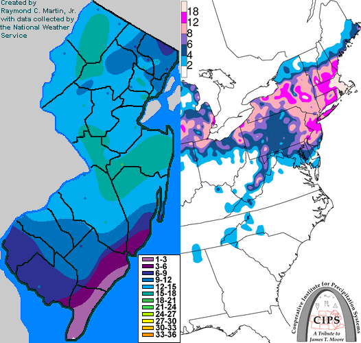
Contoured Snowfall Totals from January 22-23, 2005
STORM DESCRIPTION
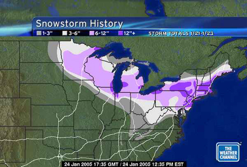
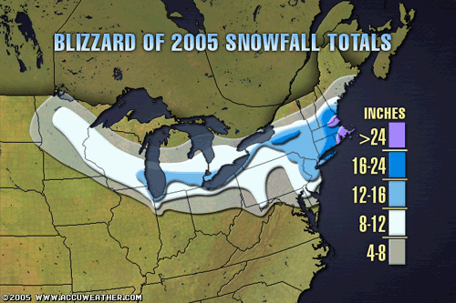
An Alberta Clipper redeveloped into a nor'easter along the Northeast coast, bringing much of New Jersey the biggest snowstorm since the Presidents Day Snowstorm of 2003.
Synoptic Discussion
A strong arctic high pressure built across the Northeast on the 21st, bringing bitterly cold air to New Jersey. Meanwhile, an Alberta Clipper low pressure system dropped southeastward from Canada across the northern Plains and Upper Midwest on the same day. The primary surface low reached Ohio on morning of the 22nd, while a new surface low began to develop near the Delmarva Peninsula. As the original surface low dissipated near Lake Erie on the evening of the 22nd, the Delmarva low became the primary low and rapidly intensified as it moved northeastward over the northwestern Atlantic. The vigorous upper-level low associated with the original Alberta surface low crossed New Jersey early on the morning of the 23rd. Both systems were southeast of Cape Cod by the evening of the 23rd.
Local Discussion
This was the heaviest snowstorm since the Presidents Day Storm of 2003 in much of New Jersey. Snow spread across the state from west to east late in the morning on the 22nd. Because the primary surface low was to the west, southeasterly surface winds developed ahead of it and attempted to push warm ocean air inland. However, the cold air mass already in place was too dense and too strongly reinforced by the arctic high pressure in Quebec. The result was a very pronounced coastal front, which developed along a line extending from near Sandy Hook in Monmouth County south-southwestward across northwestern Ocean County, southeastern Burlington County, northwestern Atlantic County, and central Cumberland County. Just southeast of the front, temperatures rose rapidly to near the freezing mark, with above freezing temperatures on the immediate southeast coast. This caused the snow that fell in these areas to be heavy and very wet, and a changeover to rain occured where temperatures were above freezing along the southeast coast. Meanwhile, very cold air remained in place farther inland. Temperatures remained in the mid-teens to lower 20s across the Delaware, Raritan and Passaic valleys, and stayed in the single digits across northwestern New Jersey. The combination of strong temperature differences, mid-level warm air overrruning, and a developing surface low resulted in very heavy snow in most of the state during the afternoon of the 22nd. The new surface low finally pulled northeast away from New Jersey on the evening of the 22nd, taking the warm air overrunning and coastal front with it. This caused the snow to taper off in most areas during the evening, but light snow and flurries lingerred in many areas. Freezing drizzle also occured over parts of southern New Jersey. During the morning hours of the 23rd, the strong upper-level low associated with the original surface low moved east across the state, causing moderate snow to redevelop in many areas. As the upper low pulled east off the coast late in the morning, the snow finally tapered off for good. Snow accumulations were heaviest in central New Jersey, with slightly lesser amounts to the north, and much less in the far southeast. Storm total snowfall ranged from 12 to 18 inches in Monmouth County, 2 to 17 inches in Ocean County, 11 to 16 inches in Somerset County, 10 to 16 inches in Essex County, 4 to 16 inches in Burlington County, 12 to 15 inches in Union, Middlesex and Mercer counties, 11 to 15 inches in Hunterdon, Warren, Morris and Sussex counties, 8 to 15 inches in Passaic and Bergen counties, 11 to 14 inches in Camden County, 9 to 14 inches in Gloucester County, 9 to 12 inches in Hudson County, 7 to 11 inches in Cumberland County, 8 to 9 inches in Salem County, 2 to 9 inches in Atlantic County, and a coating to 4 inches in Cape May County. Winds accelerated during the day of the 23rd, producing gusts to over 40 mph with considerable blowing and drifting of snow. Minor tidal flooding at the time of high tide also occured in Monmouth County on the morning of the 23rd.
New Jersey Snowfall Totals
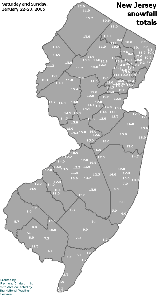
Individual Snowfall Totals from January 22-23, 2005
Regional Snowfall Totals
Snowfall Totals from 1800Z 24 January 2005 (1PM EST 24 January 2005)
Final Snowfall Totals from January 21-23, 2005
Table of Contents
Storm Summary
Regional Surface Observations
National Weather Service Forecasts
Surface Maps
Satellite Imagery
National Surface Weather Maps - Pressure and Fronts Only
Continental Surface Weather Maps - Pressure and Fronts Only
Sea Level Pressure and 1000 to 500 Millibar Thickness Maps
850 Millibar Maps
700 Millibar Maps
500 Millibar Maps
300 Millibar Maps
200 Millibar Maps
National Radar Imagery
Regional Radar Imagery
Fort Dix Doppler Radar Imagery
Storm Photos
Snow storm, December 26-27, 2004
Snow storm, January 19, 2005
Snow storm, January 22-23, 2005
Snow storm, February 20-21, 2005
Snow storm, February 24-25, 2005
Snow storm, February 28-March 1, 2005
Snow storm, March 8, 2005
Back to Ray's Winter Storm Archive
Copyright © 2012 by Raymond C Martin Jr. All rights reserved