
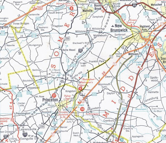
This route varied from the rejected North Jersey Expressway (I-95) proposal near the north end. The North Jersey Expressway (I-95) had been planned to travel almost due east just south of the Middlesex Freeway (I-287) and then intersect it well within Middlesex County near current Exit 5. This apparent redundancy was removed in the initial Somerset Freeway (I-95) plans shown above by instead having it intersect the Middlesex Freeway (I-287) near the Middlesex County / Somerset County border in the vicinity of current Exit 10. This route was made official in 1966 when the Middlesex Freeway (I-287) was redesignated as I-95 between the New Jersey Turnpike and current Exit 9.
At the south end of the route, the "Trenton Beltway" concept of the Scudders Falls Expressway (I-95) and the Camden Freeway (I-295) had not yet been fully conceptualized. Instead, the Camden Freeway (I-295) was proposed to curve back northwards before meeting the ends of the Scudders Falls Expressway (I-95) and the Somerset Freeway (I-95) just southeast of Pennington.
In the center, the Princeton-Hightstown Bypass (NJ 92) had been reconceptualized to form a direct link between the Somerset Freeway (I-95) and the New Jersey Turnpike (then NJ 700). The cancellation of the Somerset Freeway (I-95) would eventually help eliminate the Princeton-Hightstown Bypass (NJ 92) as well.
The 'fatal flaw' of this route is clearly visible here: it came very close to Princeton Boro and crossed well into Princeton Township. The Princeton's were the source of the outward-spiralling wave of protest against the Somerset Freeway (I-95) which would eventually result in its cancellation.
Map 1: I-95 Corridor Shifts, 1954 - 1982
Map 2: Adopted Route, 1964
Map 3: Re-extended Route, 1968
Map 4: Connectors Added, 1976
Map 5: All Considered Alignments, 1979
Map 6: Preferred Alternative Schematics and Exit List, 1979
Map 7: Exit Number Changes, 1984 - 1996
Map 8: I-95 Gap Corridor Today
Map 9: The Future I-95/I-276 Interchange
The I-95 Gap Eastern Bypass
The I-95 Eastern Route
The I-95 Western Route
The I-95 Gap Western Bypass
Back to New Jersey Expressways and Tollways