

Storm description, surface observations, snowfall totals, and images courtesy of the National Climatic Data Center, the National Centers of Environmental Prediction, the Climate Prediction Center, the Hydrometeorological Prediction Center, the Mount Holly National Weather Service Office, the Upton National Weather Service Office, Rutgers University, Plymouth State University, the University of Illinois, the American Meteorological Society, Weather Graphics Technologies, AccuWeather, and the Weather Channel.
Table of Contents
Storm Summary
Regional Surface Observations
National Weather Service Forecasts
Surface Maps
Satellite Imagery
National Surface Weather Maps - Pressure and Fronts Only
Continental Surface Weather Maps - Pressure and Fronts Only
Sea Level Pressure and 1000 to 500 Millibar Thickness Maps
850 Millibar Maps
700 Millibar Maps
500 Millibar Maps
300 Millibar Maps
200 Millibar Maps
National Radar Imagery
Regional Radar Imagery
Fort Dix Doppler Radar Imagery
Contoured Snowfall Totals from December 26-27, 2010
STORM DESCRIPTION
The "Boxing Day Blizzard of 2010" was a rapidly developing nor'easter which brought extremely heavy and in some cases record breaking snow and blizzard conditions to much of eastern New Jersey on the two days after Christmas. Significant snow also fell across western portions of the state, though both snowfall and wind was not as severe there.
Synoptic Discussion
The low pressure and associated surface fronts first developed near the Big Bend of Texas during the pre-dawn hours of Christmas Eve. During the day on Christmas Eve it tracked east across the state of Texas, reaching the northwestern Gulf of Mexico during the evening. On Christmas Day it continued tracking east just south of the northern shore of the Gulf of Mexico before coming ashore in northern Florida during the evening hours. It was only as it reached Florida that the low pressure began to strengthen significantly. By the morning of the 26th, the low pressure had continued to strengthen and had also begun to accelerate, having reached the North Carolina coast. By the evening of the 26th it had explosively intensified and was positioned just south of eastern Long Island. By the morning of the 27th it had strengthened a bit more and was located near Cape Cod. By the evening of the 27th it had reached Nova Scotia but had ceased strengthening.
Local Discussion
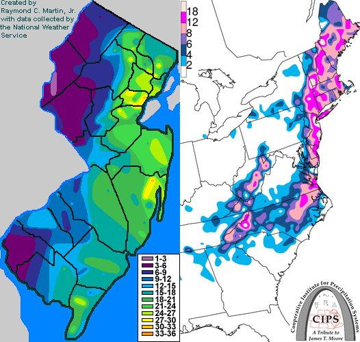
Snow began to overspread the state from southeast to northwest during the morning hours on the 26th. By the time the snow started in northwestern New Jersey during the early afternoon, it had been falling heavily for several hours already along the southern coast. The snow continued through the afternoon and evening hours of the 26th, with extremely heavy bands of snow developing across eastern New Jersey while generally lighter snowfall affected western portions of the state. Snowfall rates in eastern New Jersey reached 3 to 4 inches per hour during the evening, while rates in western New Jersey were generally 1 inch per hour or less. At the same time, winds became very strong and combined with the snow to produce blizzard conditions across the eastern half of the state, though winds were weaker across western New Jersey. After midnight on the 27th, the heaviest bands across eastern New Jersey began to weaken, but another heavy band of snow developed across southwestern New Jersey. The snow finally began to dissipate across the state during the early morning hours of the 27th, though extremely strong winds with gusts into the 50 mph range continued state-wide all day on the 27th, causing significant blowing and drifting of snow through the day. Snowfall reports varied widely due to the high winds which made measuring the snow extremely difficult. A fairly extreme east-to-west gradient in snowfall reports was also observed over northern and central New Jersey, with a huge range between the opposite ends of Morris and Somerset counties in particular. Total reported snowfall accumulations were 14 to 32 inches in Bergen, Essex, Hudson, Middlesex, Monmouth, Ocean and Union counties, 5 to 29 inches in Atlantic, Cape May, Morris, Passaic and Somerset counties, 4 to 19 inches in Burlington, Camden, Cumberland, Gloucester, Mercer and Salem counties, and 3 to 10 inches in Hunterdon, Sussex and Warren counties. Minor tidal flooding also occurred along the coast.
New Jersey Snowfall Totals
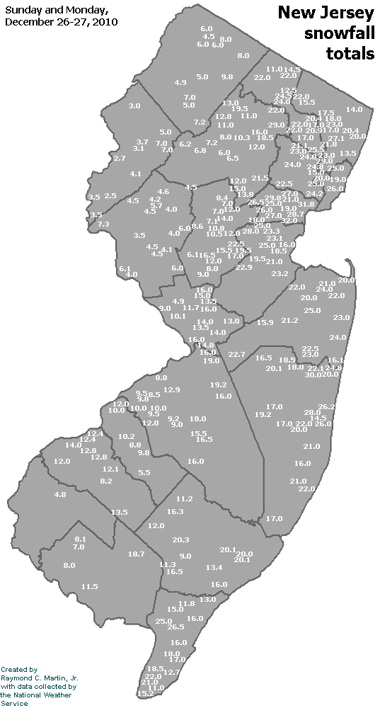
Individual Snowfall Totals from December 26-27, 2010
Regional Snowfall Totals
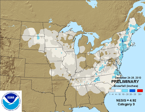
Snowfall Totals from December 26-27, 2010
Table of Contents
Storm Summary
Regional Surface Observations
National Weather Service Forecasts
Surface Maps
Satellite Imagery
National Surface Weather Maps - Pressure and Fronts Only
Continental Surface Weather Maps - Pressure and Fronts Only
Sea Level Pressure and 1000 to 500 Millibar Thickness Maps
850 Millibar Maps
700 Millibar Maps
500 Millibar Maps
300 Millibar Maps
200 Millibar Maps
National Radar Imagery
Regional Radar Imagery
Fort Dix Doppler Radar Imagery
Snow storm, December 26-27, 2010
Snow storm, January 7, 2011
Snow storm, January 8, 2011
Snow storm, January 11-12, 2011
Snow and ice storm, January 17-18, 2011
Snow storm, January 21, 2011
Snow and ice storm, January 26-27, 2011
Snow storm, February 21-22, 2011
Back to Ray's Winter Storm Archive
Copyright © 2012 by Raymond C Martin Jr. All rights reserved