

Storm description, surface observations, snowfall totals, and images courtesy of the National Climatic Data Center, the National Centers of Environmental Prediction, the Climate Prediction Center, the Hydrometeorological Prediction Center, the Mount Holly National Weather Service Office, the Upton National Weather Service Office, Rutgers University, Plymouth State University, the University of Illinois, the American Meteorological Society, Weather Graphics Technologies, AccuWeather, and the Weather Channel.
Table of Contents
Storm Summary
Regional Surface Observations
National Weather Service Forecasts
Surface Maps
Satellite Imagery
National Surface Weather Maps - Pressure and Fronts Only
Continental Surface Weather Maps - Pressure and Fronts Only
Sea Level Pressure and 1000 to 500 Millibar Thickness Maps
850 Millibar Maps
700 Millibar Maps
500 Millibar Maps
300 Millibar Maps
200 Millibar Maps
National Radar Imagery
Regional Radar Imagery
Local Radar Imagery
Fort Dix Doppler Radar Imagery
Storm Photos
Contoured Snowfall Totals from December 5, 2002
STORM DESCRIPTION
The first winter storm of the season droped 4 to 10 inches of snow across most of New Jersey with somewhat lower amounts along the immediate coast. In many places across the southern half of the state, the snow that fell in this first storm was more than all the snow that fell in the previous winter.
Synoptic Discussion
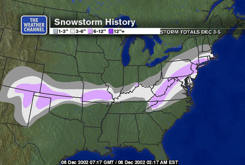
On Wednesday, December 4th, an area of low pressure started to develop along an old frontal boundary that snaked across the northern Gulf of Mexico and Gulf Coast states. Meanwhile, high pressure stretched from the northern Plains, across the Great Lakes and into the Mid-Atlantic, effectively locking cold air into the Northeast. During the night of the 4th, the developing storm moved across the Southeastern states to the North Carolina coast. Shortly after daybreak on Thursday, December 5th, the storm started to move off the coast near Cape Hatteras. It then accelerated quickly off-shore during the day on the 5th.
Local Discussion
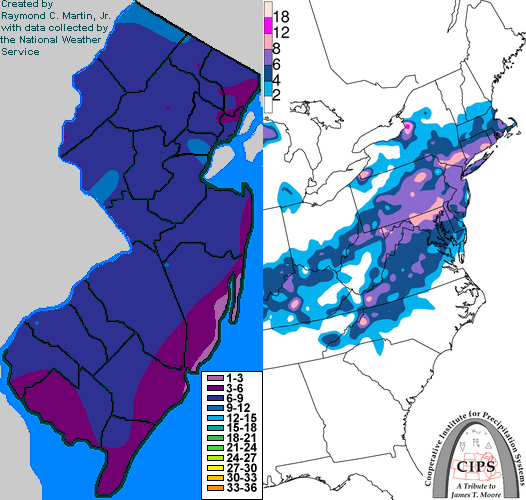
The snow spread across the state from southwest to northeast between 3 AM EST and 8 AM EST on the 5th. The snow mixed with and then changed to sleet and rain during the afternoon of the 5th across southeastern sections of the state. Some sleet also mixed with the snow in other coastal areas further north. Precipitation fell as all snow elsewhere in the state. The heaviest snow fell in the south during the morning and just after midday in northern portions of New Jersey. Precipitation ended during the first half of the evening. Accumulations ranged from 5 to 9 inches across Sussex, Warren, Morris, Passaic, Bergen, Essex, Hudson, Union, Somerset, Hunterdon, Mercer, Middlesex, Monmouth, Burlington, Camden, Gloucester, Salem, and Cumberland counties; 3 to 8 inches across Ocean County, and 3 to 6 inches across Atlantic and Cape May counties.
New Jersey Snowfall Totals
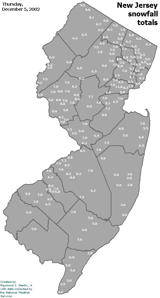
Individual Snowfall Totals from December 5, 2002
Regional Snowfall Totals
Snowfall Totals from 0700Z 06 December 2002 (2AM EST 06 December 2002)
Table of Contents
Storm Summary
Regional Surface Observations
National Weather Service Forecasts
Surface Maps
Satellite Imagery
National Surface Weather Maps - Pressure and Fronts Only
Continental Surface Weather Maps - Pressure and Fronts Only
Sea Level Pressure and 1000 to 500 Millibar Thickness Maps
850 Millibar Maps
700 Millibar Maps
500 Millibar Maps
300 Millibar Maps
200 Millibar Maps
National Radar Imagery
Regional Radar Imagery
Local Radar Imagery
Fort Dix Doppler Radar Imagery
Storm Photos
Snow storm, December 5, 2002
Snow and ice storm, December 24-26, 2002
Snow storm, January 5, 2003
Snow storm, January 16-17, 2003
Snow storm, January 29, 2003
Snow storm, February 6-7, 2003
Snow storm, February 16-17, 2003
Snow storm, February 27-28, 2003
Snow and ice storm, March 6, 2003
Snow and ice storm, April 7, 2003
Back to Ray's Winter Storm Archive
Copyright © 2012 by Raymond C Martin Jr. All rights reserved