

Storm description, surface observations, snowfall totals, and images courtesy of the National Climatic Data Center, the National Centers of Environmental Prediction, the Climate Prediction Center, the Hydrometeorological Prediction Center, the Mount Holly National Weather Service Office, the Upton National Weather Service Office, Rutgers University, Plymouth State University, the University of Illinois, the American Meteorological Society, Weather Graphics Technologies, AccuWeather, and the Weather Channel.
Table of Contents
Storm Summary
Regional Surface Observations
National Weather Service Forecasts
Surface Maps
Satellite Imagery
National Surface Weather Maps - Pressure and Fronts Only
Continental Surface Weather Maps - Pressure and Fronts Only
Sea Level Pressure and 1000 to 500 Millibar Thickness Maps
850 Millibar Maps
700 Millibar Maps
500 Millibar Maps
300 Millibar Maps
200 Millibar Maps
National Radar Imagery
Regional Radar Imagery
Local Radar Imagery
Fort Dix Doppler Radar Imagery
Storm Photos
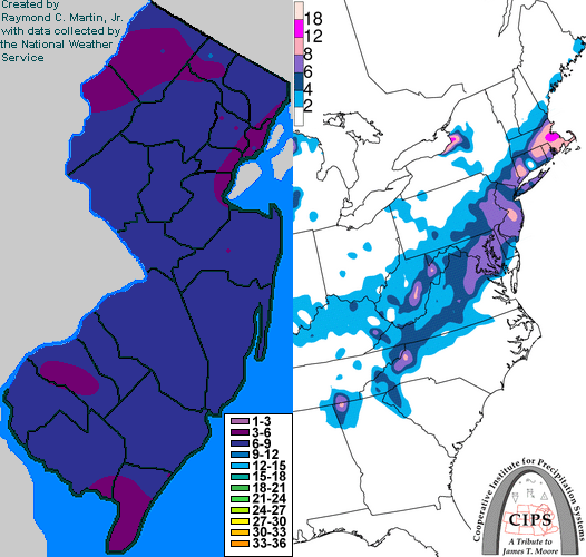
Contoured Snowfall Totals from February 6-7, 2003
STORM DESCRIPTION
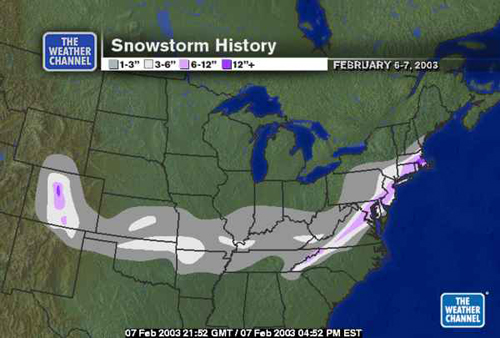
A fast moving winter storm dropped 4 to 9 inches of snow across most of the Garden State, with slightly lesser amounts in the far south.
Synoptic Discussion
Low pressure formed on the Gulf Coast during the day on the 6th and quickly moved northeast to Elizabeth City, North Carolina by the morning of the 7th. It was well off shore by the evening of the 7th. The storm itself was rather weak and also moved quite fast, but precipitation was intensified by a subtropical jetstream which brought additional moisture from the Pacific Ocean.
Local Discussion
Snow spread across the state from southwest to northeast during the evening hours of the 6th. The snow continued to gradually intensify overnight, reaching peak intensity during the early to mid morning hours of the 7th. There was some mixing with sleet and rain across parts of Cape May County during the morning of the 7th, but the rest of the state recieved all snow. The snow tapered off from southwest to northeast during the midday and early afternoon of the 7th. Total snow accumulations were 6 to 9 inches in Passaic, Ocean, Burlington, Camden, and Atlantic counties, 5 to 8 inches in Sussex, Warren, Morris, Essex, Bergen, Hudson, Union, Middlesex, Monmouth, Mercer, Gloucester, Salem, and Cumberland counties, 4 to 7 inches in Hunterdon and Somerset counties, and 3 to 6 inches in Cape May County.
New Jersey Snowfall Totals
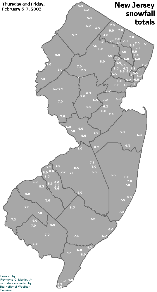
Individual Snowfall Totals from February 6-7, 2003
Regional Snowfall Totals
Snow Totals from 2200Z 07 February 2003 (5PM EST 07 February 2003)
Table of Contents
Storm Summary
Regional Surface Observations
National Weather Service Forecasts
Surface Maps
Satellite Imagery
National Surface Weather Maps - Pressure and Fronts Only
Continental Surface Weather Maps - Pressure and Fronts Only
Sea Level Pressure and 1000 to 500 Millibar Thickness Maps
850 Millibar Maps
700 Millibar Maps
500 Millibar Maps
300 Millibar Maps
200 Millibar Maps
National Radar Imagery
Regional Radar Imagery
Local Radar Imagery
Fort Dix Doppler Radar Imagery
Storm Photos
Snow storm, December 5, 2002
Snow and ice storm, December 24-26, 2002
Snow storm, January 5, 2003
Snow storm, January 16-17, 2003
Snow storm, January 29, 2003
Snow storm, February 6-7, 2003
Snow storm, February 16-17, 2003
Snow storm, February 27-28, 2003
Snow and ice storm, March 6, 2003
Snow and ice storm, April 7, 2003
Back to Ray's Winter Storm Archive
Copyright © 2012 by Raymond C Martin Jr. All rights reserved